James Reeder | USCT

Known Information

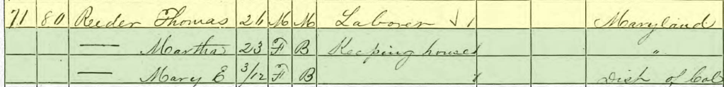
James Reeder had an account in the Freedmen’s Bank. He identified his wife and child and mother on the depositor slip. Additionally, he identified St. Mary’s County as his birth place.

Sources

Plan of Fort Monroe

Sneden, Robert Knox. Plan of Fortress Monroe, Virginia, March 6. [to 1865, 1862] Map. https://www.loc.gov/item/gvhs01.vhs00203/.

Service Records

The National Archives at Washington, D.C.; Washington, D.C.; Compiled Military Service Records of Volunteer Union Soldiers Who Served with the United States Colored Troops: 1st through 5th United States Colored Cavalry, 5th Massachusetts Cavalry (Colored), 6th United States Colored Cavalry; Microfilm Serial: M1817 | ancestry.com

Service records show that James Reeder served in Company K of the 1st US Calvary of Colored Troops, which was attached to Camp Hamilton at Fort Monroe in Virginia.

Fort Monroe

Stampede of slaves from Hampton to Fortress Monroe. United States Fort Monroe Hampton Virginia, 1985. [? from a Print In1861] Photograph. https://www.loc.gov/item/92515012/.

His services records indicate that he enlisted in February of 1864. One sheet indicates Camp Nixon which was north of Georgetown near District of Columbia, and the second sheet indicates Fort Monroe. It is possible that he made his way to DC from St. Mary’s and then was dispatched to Fort Monroe once he enlisted, as his arrival in Fort Monroe is recorded as Mar 1864.

Fort Monroe sits near Hampton Roads and guards the harbor at Old Point Comfort. In 1861, three enslaved men escaped their bondage and asked Gen. Butler to harbor them rather than return them to their enslavers. Butler contended that since the enslavers were in open rebellion against the US, the enslaved were “contraband of war” and did not need to be returned. As a result, the enslaved made their way to Fort Monroe to free themselves from slavery, the media calling it a “stampede”. The Fort became known as “Freedom’s Fortress”. Gen. Butler helped to establish camps for the freedpeople, providing clothing and food, and finding jobs and training for them. Several of the refugees joined the military. This cartoon from the 1860s (drawn with racist tropes in its imagery and language) depicts the “contraband” policy that Butler established.

He was nineteen when he enlisted. His service records do not document any injuries or illness, suggesting that he stayed with his company throughout the war. During May of 1864, it indicates that his company was dispatched to guard cattle, a common duty when the US Army first starting enlisted Black men into the US Army during the Civil War, especially along the James River and the road up to DC from Richmond.

He died in 1897 and was buried in section 27 of Arlington National Cemetery.

Further Research Needed:

  • Research the 1st Regiment of the US Colored Calvary

related posts

The Reeders | Freedmen’s Bank Records

Known Information

Thomas and John Reeder owned property together on 1st St NW

Sources

Bank Records

Registers of Signatures of Depositors in Branches of the Freedman’s Savings and Trust Company, 1865-1874. Washington, D.C.: National Archives and Records Administration. Micropublication M816, 27 rolls | ancestry.com

Freedman’s Savings and Trust Company’s was established to allow freedmen to deposit their savings in 1865; it closed in 1874 due to mismanagement. The bank kept records of depositors which included some demographic data including place of birth and family members.

These records show the family connections between the James Reeder family with the Mary Fountain family.

Further Research Needed:

  • Locate the Reeder family in St. Mary’s County
  • Locate the siblings in the 1870 Census
  • Locate marriage records for the Reeder siblings, esp James, Mary, and Thomas

related posts

Martha Reeder | Freedman’s Bureau

Known Information

Thomas and Martha Reeder were living in DC during the 1870 census.

Sources

Print

Taylor, James E., Artist. Glimpses at the Freedmen’s Bureau. Issuing rations to the old and sick / from a sketch by our special artist, Jas. E. Taylor. Richmond Virginia, 1866. Photograph. https://www.loc.gov/item/2009633700/

Freedman’s Village, Arlington i.e., Alexandria, Va. United States Arlington Alexandria Virginia, None. [Photographed between 1861 and 1865, printed between 1880 and 1889] Photograph. https://www.loc.gov/item/2014645761/

Map

Boschke, A, D McClelland, Hugh B Sweeny, Thos Blagden, and Blanchard & Mohun D. Mcclelland. Topographical map of the District of Columbia. Washington: D. McClelland, Blanchard & Mohun, 1861. Map. https://www.loc.gov/item/88694013/

United States, Freedmen’s Bureau Ration Records,1865-1872

District of Columbia, United States, NARA microfilm publications M1055. Records of the Bureau of Refugees, Freedmen, and Abandoned Lands, 1861 – 1880, RG 105. (Washington, D.C.: National Archives and Records Administration, 1969-1980); roll 16 | familysearch.org

Newspapers

The Baltimore Sun 
Baltimore, Maryland
14 Jan 1868, Tue  •  Page 4

The Freedman’s Bureau was a US government agency from 1865-1872 charged with directing provisions, clothing, fuel “for the immediate and temporary shelter and supply of destitute and suffering refugees and freedmen and their wives and children”

The Bureau kept records of what provisions, or rations were distributed.

In 1868, they recorded that Martha Reeder was provided $2.00 worth of groceries as she was unemployed. They listed her residence as Kendall Green. In addition to Martha, Cora Reeder was also recorded as residing at Kendall Green and receiving rations due to sickness.

This sketch is of a Richmond Bureau Office distributing rations “to the old and sick”

Kendall Green

After the Civil War, the US Government converted military barracks into housing for freepeople. Kendall Green Barracks, located on the northeast boundary of the city was one of the converted barracks. Kendall Green was located along Boundary Ave, in the northeast quadrant of the city. On the map, it is directly “north” of the capitol building, between Delaware and Maryland Avenues. The northern edge of the camp was at M and Boundary Ave.

In 1867, Kendall Green became the housing for the freed people who were unable to pay their rent and the Freedmen’s Bureau began to transfer nonpaying tenants and “those that pay very irregularly” to Kendall Green and those who could pay to housing closer to the city. In a newspaper article, the barracks are described a light one-story frame tenements with twenty-one rooms, housing 250 freedpeople.

Picture of the school established at Freedmen’s Village in Alexandria, VA

These barracks have been fitted up for dwellings for the freed people to be rented for very low rates, in order to get them out of the wretched shanties in which such numbers of them have hitherto lived (and died). But they are located so far from one side of the city, that they are taken up slowly.

Letter from A. E. Newton reporting on the school built near Kendall Green Barracks as listed in the National Freedman, A Monthly Journal, Vol 11, No 5 May 1866 (147)

Further Research Needed:

  • Determine the relationship between Martha and Cora Reeder
  • Identify other Reeders recorded in the Freedmen’s Records

related posts

Thomas Reeder | property on 1st Street NW

Known Information

James Reeder came to DC during the Civil War.

Sources

1870 Census

1870; Census Place: Washington Ward 3, Washington, District of Columbia;Roll: M593_124; Page: 449B

Map

Boschke, A, D McClelland, Hugh B Sweeny, Thos Blagden, and Blanchard & Mohun D. Mcclelland. Topographical map of the District of Columbia. Washington: D. McClelland, Blanchard & Mohun, 1861. Map. https://www.loc.gov/item/88694013/.

City Directory

Washington, District of Columbia, City Directory, 1870-1878, exclusive of 1872 which is incomplete

Newspapers

Evening Star 
Washington, District of Columbia
24 Jun 1867, Mon  •  Page 4

Evening Star 
Washington, District of Columbia
26 Sep 1872, Thu  •  Page 22

In 1870, Thomas Reader is listed in the City Directories as living at 1421 1st NW; he was living with his wife and infant daughter. The city directory listed him as a waiter, the census as a laborer. Marriage records in DC show the Thomas and Martha were married three year earlier in 1867.

His residence was almost to the edge of the official City of Washington. Located at O and 1st street NW, it was just a few blocks from Boundary Ave (now Florida Ave), which served as the boundary between the city and the county. This area of the City was still agricultural in nature, especially in comparison to the areas around Pennsylvania Avenue near the Capitol and the White House. The houses are sparser and farther apart. Large agricultural estates still dominated the landscape of the County, though a few were being broken into subdivisions, like Le Droit Park. In 1888, when Sanborne made Fire Insurance maps for the City of Washington, square 616 and its environs were not included in the atlas, presumably because there were not enough properties, or properties to be insured, built in this neighborhood. The Topographical map shows the contrast in population density between the area near Boundary Avenue and closer to the Capitol. Square 616 is two blocks south of Mrs. E Beale’s property.

In 1872, the Evening Star ran tax assessments on properties in the City, showing that Thomas and John Reeder owned part of lot 12 of square 616 in the city. That specific property had been put up for sale in 1867. Auctioners Cooper and Latimer advertised it as “unimproved property”. This suggests that when the property bought there were minimal buildings on the lot.

The city directories show that Thomas lived in an about 1421 1st NW throughout the 1870s until 1878:

  • 1871: 1417 1st NW
  • 1873: 1423 1st NW
  • 1874: 1421 1st NW
  • 1875: 1st near P NW
  • 1876: 1421 1st NW
  • 1877: 1419 1st NW

Further Research Needed:

  • Identify the relationship of John Reeder to Thomas Reeder
  • Locate the land records in the DC Archives

related posts

Thomas Reeder | Jackson alley

Known Information

Thomas Reeder lived in DC after the Civil War.

Sources

Newspapers

Evening Star 
Washington, District of Columbia
23 Jul 1866, Mon  •  Page 2

Evening Star 
Washington, District of Columbia
13 Jul 1867, Sat  •  Page 3

Evening Star 
Washington, District of Columbia
27 Jul 1867, Sat  •  Page 3

Evening Star 
Washington, District of Columbia
26 Sep 1867, Thu  •  Page 3

Evening Star 
Washington, District of Columbia
07 Jun 1873, Sat  •  Page 4

Evening Star 
Washington, District of Columbia
24 Dec 1877, Mon  •  Page 2

Map

Gamble, W. H, and S. Augustus Mitchell. Plan of the city of Washington: the capitol sic of the United States of America. [Philadelphia: S. Augustus Mitchell Jr, 1869] Map. https://www.loc.gov/item/88693479/

Sanborn Fire Insurance Map from Washington, District of Columbia, District of Columbia. Sanborn Map Company, 1888. Map. https://www.loc.gov/item/sanborn01227_001/.

City Directory

Washington, District of Columbia, City Directory, 1864

Print

Kollner, Augustus, Artist. Tiber Creek north-east of the Capitol. Washington, D.C. Washington D.C. United States Tiber Creek, 1839. Photograph. https://www.loc.gov/item/2004662005/

Currier & Ives, Publisher, and Charles R Parsons. The City of Washington birds-eye view from the Potomac-looking north / drawn by C.R. Parsons. United States Washington D.C. District of Columbia Washington, ca. 1880. New York: Published by Currier & Ives. Photograph. https://www.loc.gov/item/90716011/

Swampoodle

The Tiber Creek ran northeast of the Capitol, no longer a contained canal. When there were storms, the creek often flooded, washing away bridges and filling basements. Due to the swampy nature of this floodplain and the left behind puddles, the area near the Union Pr. Office was called Swampoodle.

In this rendering of Washington, Massachusetts Ave intersects with North Capitol Street near the center seam of the picture. The blocks north of this intersection was called Swampoodle and contained Jackson Alley.

Jackson Alley was considered the heart of Swampoodle, and ran between G and H street, along the Printing Office. Originally an Irish enclave, when refugees from slavery arrived in the City of Washington during the Civil War, African-American families also found homes in Swampoodle.

1880 Census

In the 1880 Census, Thomas Reeder was recorded living with his family with Robert Childs and his family in 71 Jackson Alley. Thomas and his wife Martha had three children: Mary E, 10, Joseph, 8, and Georgiana, 4. Thomas and his wife, Martha, were born in Maryland while their children were all born in DC.

Mary E. is marked as having attended school.

The City Directories for 1883-1901 show Thomas living at various addresses in Jackson Alley; sometimes at #65, or #50, or #34. The variety of house numbers suggests that the Reeder family shifted as rent prices and space shifted in the alley. The excerpt from the Sanborn Fire Insurance maps shows the variation in size and that some homes were frame and some were brick. The end of the block near the Printing Office was more industrial in nature, containing a livery station, a factory and storehouse.

Further Research Needed:

  • Locate residences in earlier censuses

related posts

Ernest S Wedge | USS Raleigh

Known Information

Ernest lists his occupation as a cleaner and dryer on his WW II Draft Card.

Sources

World War II Draft Card

The National Archives in St. Louis, Missouri; St. Louis, Missouri; WWII Draft Registration Cards for District of Columbia, 10/16/1940-03/31/1947; Record Group: Records of the Selective Service System, 147; Box: 241

Internment Card

U.S., National Cemetery Interment Control Forms, 1928-1962

Muster Rolls

Muster Rolls of U.S. Navy Ships, Stations, and Other Naval Activities, 1/1/1939 – 1/1/1949

Ernest Wedge served in the US Navy during World War II. He had the rank of Stewards Mate 1/C. He enlisted in 1943 and was honorably discharged in December of 1945. He died in 1949; he was buried in Arlington National Cemetery, section 34. His muster records indicate that he first came aboard in 14 Mar 1944, indicating he attended training between November 1943 and March 1944.

World War II

Ernest served on the USS Raleigh, a light cruiser that had been damaged at Pearl Harbor. It was overhauled and repaired. In 1942 it was returned to service in the Aleutian Islands.

U.S. Navy photo 19-N-30916

The Japanese invaded the islands in 1942 and American forces recaptured Attu in June of 1943. U.S. troops remained in the Aleutians until the end of the war in 1945. 

Map from nps.gov

Messman/Steward Branch

The US Navy only allowed non-white sailors to serve in the Messman/Steward Branch, which was responsible for feeding and serving officers. Ernest served as a Steward’s Mate First Class. This rank was originally called a mess attendant.

Further Research Needed:

  • Locate more detailed service records from the National Archives

related posts

Ernest S Wedge | proprietor of Valet Shop

Known Information

Ernest Wedge is listed as the son of James and Emma Wedge in the 1920 census.

Sources

1940 Census

940; Census Place: Washington, District of Columbia, District of Columbia;Roll: m-t0627-00558; Page: 10B | ancestry.com

World War II Draft Card

The National Archives in St. Louis, Missouri; St. Louis, Missouri; WWII Draft Registration Cards for District of Columbia, 10/16/1940-03/31/1947; Record Group: Records of the Selective Service System, 147; Box: 241

City Directory

Washington, District of Columbia, City Directory, 1938-1939 | ancestry.com

Newspaper

Evening Star 
Washington, District of Columbia
13 Jun 1934, Wed  •  Page 32

Ernest is listed in the household of his mother Emma Diggs in the 1940 census. His occupation is listed as a proprietor of a valet shop. His sister, Catherine, is listed as a clerk in a valet shop.

Location of Shop

His World War II Draft Registration card lists himself as his employer and that he is a “cleaner and dyer”. The address listed is close to Eastern Market and next door to where William H. Graham lived (303 7th Street SE).

In the screenshot from Google Maps, 303 7th Street is the red brick building. 301 is the cream building. Eastern Market can be seen in the background.

Prior to Valet Shop

In the 1938 and 1939 City Directories of Washington DC, his employer was Woodward & Lothrop, a large department store in DC. He was employed first as a porter and then a helper.

Woodward & Lothrop employed tailors, pressers and other service employees. As a helper, he may have worked in the Valet department.

Further Research Needed:

  • Locate a 1940 City Directory to determine name and other details for the Valet Shop

related posts

George R Dent | son of Bruce Dent

Known Information

George Dent is listed in the household of Bruce Dent in the 1860 census.

Newspaper Sources

Evening Star 
Washington, District of Columbia
27 Nov 1868, Fri  •  Page 4

National Republican 
Washington, District of Columbia
04 Dec 1868, Fri  •  Page 3

Evening Star 
Washington, District of Columbia
29 Jan 1869, Fri  •  Page 4

National Republican 
Washington, District of Columbia
30 Jan 1869, Sat  •  Page 4

Evening Star 
Washington, District of Columbia
25 May 1874, Mon  •  Page 4

Evening Star 
Washington, District of Columbia
24 Sep 1878, Tue  •  Page 4

Evening Star 
Washington, District of Columbia
10 Mar 1879, Mon  •  Page 4

National Republican 
Washington, District of Columbia
18 Nov 1879, Tue  •  Page 3

National Republican 
Washington, District of Columbia
02 Feb 1884, Sat  •  Page 6

Evening Star 
Washington, District of Columbia
18 Dec 1889, Wed  •  Page 10

The Critic 
Washington, District of Columbia
09 Oct 1890, Thu  •  Page 1

Evening Star 
Washington, District of Columbia
10 Oct 1890, Fri  •  Page 2

The Evening Times 
Washington, District of Columbia
13 Aug 1897, Fri  •  Page 5

The Evening Times 
Washington, District of Columbia
13 Aug 1897, Fri  •  Page 6

Evening Star 
Washington, District of Columbia
28 Sep 1901, Sat  •  Page 3

  • 1844-5 | Estimated Birth Year

    George was born in DC.

    Based on the 1850 & 1860 Census

  • 1850 | Residence in Ward 7 of Washington City

    He is living with his parents, Bruce and Cassandra Dent, in Ward 7 of DC.

    According to the census, George attended school, most likely founded by Enoch Ambush, who ran a school for Black children in southwest DC. Ambush ran a school at 10th and E Street. Additionaly, Ambush was a friend of Anthony Bowen who helped form one of the few schools for free blacks, the “Sunday Evening School”, in the Wesley Church, now the Metropolitan A.M.E.Z. Church on D Street SW.

    Based on the 1850 Census

  • 1860 | Residence in Ward 7 of Washington City

    He is living with his parents, Bruce and Cassandra Dent, in Ward 7 of DC. He is a teenager now, although no occupation is listed for him.

    Based on the 1860 Census

  • 1868-1869 | Arrest

    In Nov 1868, the Evening Star reports that “large crowd of colored population assembled near the Lincoln Barracks” to witness the laying of a cornerstone for “East Mission”, of Israel Methodist Episcopal Church. “There was considerable confusion and disturbance in the outskirts of the crowd during the evening confined principally to boys, and with that exception everything passed off quietly and peaceably.”

    In Dec 1868, the National Republican reports that George Dent was arrested on suspicious of participation in riot near Lincoln Barracks on Thanksgiving Day.

    In Jan 1869, the Evening Star reports that he was sentenced to three months in jail for resisting arrest. In the National Republican, it was reported that Geo Dent, Geo Poole, and Barney Clinkett were found guilty and Clinkett was sent to jail for 39 days for the riot, while Dent when away for three months for resisting arrest.

  • 1869 | Driver

    He is listed in the City Directory as a driver. He is living at the address that is consistent with Bruce Dent in the 1860s, 585 3d W.

  • 1870 | Residence in Ward 7

    George is living in the household of Silas and Fannie Greeley. Cyrus Greeley is listed in the 1871 City Directory as a cook living at 209 F SW. George is living about a block east of his father’s home on 3rd Street.

  • 1870s | Bricks

    In 1872, he is listed as a bricklayer at 513 3rd St SW. This is his father’s address, after DC updated the numbering system for addresses in 1869. In 1877, he is listed as bricklayer living in Willow Tree Alley, which is located between B and C and 3d and 4 1/2 SW.

    1910 Photograph of Willow Tree Alley as it appeared in the Washington Times | the alley was razed in 1913

  • 1874 | Affair & Arrest

    In May 1874, The Evening Start reported that Louisa Edelin, George Dent and Isabella Dent were arrested for assault and battery on John Edelin. The article reports that George Dent and Louisa Edelin (John’s wife) had been having an affair and when John found out, he addressed the trio. They assaulted him with paving stones. In Dec of 1874, George was fined $5 for his part in the assault.

  • 1878 | Arrest for Assault

    In Sept 1878, The Evening Start reported that George Dent, a hackman, was charged with assault and battery with intent to kill; he was arrested for a dispute over change from a newspaper that the boy was selling at the Baltimore and Potomac Railroad Depot. The Depot was located in Armory square, at 6th and B NW, immediately southeast of Center Market. The defense was able to show that the incident was an accident.

    Baltimore and Potomac Railroad Station | DC Public Library

  • 1879 | Profane Language and Vagrancy

    In 1879, George R. Dent was arrested twice, once for profane language, and for vagrancy for which he “was sent down to the farm.”

  • 1880 | Residence in Ward 7 of Washington City

    He is living in the household of Emma Johnson and Emma Walker, near Willow Tree Alley, on 4 and 1/2 Street. In 1882, the Critic reported that George pleaded guilty for assaulting Emma Walker and spent 7 days in jail.

    Based on the 1880 Census

  • 1884 | Soliciting fares

    In 1884, Geo. Dent was charged with soliciting hack fares in the Capitol Grounds, as reported in the National Republican.

  • 1889 | Disorderly Conduct

    In 1889, the Evening Star reported that “a small bald-headed” George Dent was charged with disorderly conduct at the Fisherman’s hall. The Order of Galilean Fisherman was a benevolent society established after the Civil War to help the newly emancipated Black people. It stressed equality and financial literacy. The map is an excerpt from Baist’s real estate atlas and shows square 538, where Bruce Dent held property in the 1850’s and 1860s. George lived in lots 26 of this square in the 1870. The Temple of Galillean Fisherman can be seen in the north half of square 539, off of F street.

  • 1890 | Fast driving

    In 1890, George Dent was accused of driving fast (faster than 8mph). He was a hackman who drove a Surrey and picked up fares at the Baltimore and Potomac Depot. A lawyer for Dent claimed that the animal could go that fast as he had driven him and was lame in one foot. The officer countered that the horse the lawyer had tested wasn’t the animal the Dent had driven. Dent was charged $5.

    Surrey, 1900; in the Suffolk Museum and Carriage House, Stony Brook, Long Island, N.Y. | Encyclopædia Britannica

  • 1897 | Accident at Brickmaker Factory

    The Evening times reported that George Dent fell from a kiln at Ford’s brickyard. He sustained a head injury and was taken to Providence Hospital.

  • 1900 | Residence in northeast DC | Schott’s Alley

    He is living in the household of Harry Hall. His occupation is listed as a hackman and his birth month is recorded as June.

    Based on the 1900 Census

  • 1901 | Death Reported

    His death is reported in the Evening Star.

Further Research Needed:

  • Locate his death certificate from DC Archives
  • Research connections between George Dent and the names reported with him in the articles

related posts

Bruce Dent | Nonesuch property

Known Information

Bruce Dent owned property in DC during the 1850s and 1860s. He is listed as living “East of Seventh Street” in the 1870 Census.

Sources

1870 Census

1870; Census Place: East of Seventh Street, Washington, District of Columbia; Roll: M593_127; Page: 726B

Map

Map of the District of Columbia including the cities of Washington, Georgetown, and Alexandria, Virginia. [Washington?: s.n, 1873] Map. https://www.loc.gov/item/88693472/.

A complete set of surveys and plats of properties in the city of Washington, District of Columbia, 1887, plate 44 | DC Library

Newspapers

National Republican 
Washington, District of Columbia
24 Jul 1875, Sat  •  Page 9

The Critic 
Washington, District of Columbia
19 Jan 1889, Sat  •  Page 17

Washington Times 
Washington, District of Columbia

20 Mar 1896, Fri  •  Page 3

Secondary Sources

Rural Remnants of Washington County: An Architectural Survey of Washington’s Historic Farms and Estates | DC Planning Commission

Anacostia Neighborhood Museum., & Hutchinson, L. D. (1977). Anacostia Story: 1608-1930. Washington: Smithsonian Institution Press.

East of the River: Continuity and Change by Portia James

Bruce Dent is listed as a farmer in the 1870 census; he is listed in the district “East of Seventh Street”, encompassing the large agricultural tracts beyond the city boundary. In the map, this district is reflected by the First District and eastern part of Second District. Seventh Street can be identified by the subdivision of Mt. Pleasant and Howard University.

Bruce Dent is listed in the National Republican for delinquent taxes for 5 acres of property in Nonesuch in 1875 (24 Jul 1875, p 9). His property borders I. M. Young’s property as well as the Trimble Tract.

Nonesuch

George Washington Young, the grandson of Notley Young, owned property across the Eastern Banch. He owned both Giesborough Manor and Nonesuch prior to the war. He inherited Nonesuch (both the mansion and the estate) in 1826 and purchased the Giesborough tract in 1833. The Nonesuch estate was along the Oxon Run watershed. Young had a house built for his daughter Mary upon her marriage to Col. Denman.

Hopkins, Griffith Morgan, Jr. Atlas of fifteen miles around Washington, including the County of Prince George, Maryland. Philadelphia: G.M. Hopkins, 1878.

The residence of both Young and Denmead can be seen on the southern part of this excerpt from Plate 77 of the Hopkins Map. It is along Bowen Road. Bruce Dent is also labeled along Bowen Road, his name on the right side of the road.

This corresponds with City Directories that lists him as living on Bowen Road, which was named for Sayles Jenk Bowen, elected mayor in 1868 and a staunch supporter of civil rights for Black people.

The excerpt from the 1887 Plat Book shows the size and relative location of the property along Bowen Road. In 1889, the Critic lists properties with assessed taxes, and includes his property, identifying it as plat 24, Nonsuch. (19 Jan 1889, page 17)

In 1896, The Washington Times reported that Bruce transferred 2 acres of the land to Benjamin Boyd.

Further Research Needed:

  • Locate the land records in the DC Archives
  • Identify Bruce Dent’s relationship to Benjamin Boyd

related posts

Bruce Dent | the Island property

Known Information

Bruce Dent is listed in the 1860 census with real estate valued at $750; he was a huckster who sold produce in the market.

Sources

Map

Tanner, Henry Schenck, and S. Augustus Mitchell. City of Washington. [Philadelphia: S. Augustus Mitchell, 1846] Map. https://www.loc.gov/item/88694050/

Keily, James, and Lloyd Van Derveer. Map of the city of Washington D.C.: established as the permanent seat of the government of the U.S. of Am. Camden, N.J.: Lloyd Van Derveer, 1851. Map. https://www.loc.gov/item/88694049/.

Tax Assessments

Appendix 3, p. 162 of Brown, L. W. (1972). Free negroes in the district of Columbia 1790-1846. New York U.P.

City Directory

Washington, District of Columbia, City Directory, 1864

The Island

Southwest DC was called the Island as a result of the Tiber Creek and James Canal which effectively cut it off from the rest of the City. Most of the land in southwest DC had been part of Notley Young’s plantation, which had been donated to the government for the city. James Greenleaf, a real estate speculator, purchased the land from the government in return for a promise to build ten new homes a year. He was unable to deliver that promise as he was unable to secure funds. The land, cut off by the canal, was slow to develop in the 1800s. It contained old plantations, industrial facilities and assortment of workmen’s homes. The southern most point was called Greenleaf Point.

King, N. Map of part of the city of Washington, shewing the situation of the mansion house, grave yard & buildings, belonging to Mr. Notley Young: original proprietor of that part of the city. [Washington, D.C.?: s.n., ?, 1796] Map. https://www.loc.gov/item/88693256/.

In 1845, Bruce Dent was listed in the District of Columbia Tax Records. He was assessed for property in square 499 at $1.50. The 1850 census listed his real estate valued $246

Square 499 was along 4 1/2 Street which was a thoroughfare through The Island. The map excerpt from 1851 shows how few improvements had been made to the lots in that part of DC, as more of the buildings and properties had been built closer to the Mall and near the wharves and Long Bridge. This suggests that the property in Square 499 had space that allowed for growing produce and/or raising livestock. the 1888 Sanborn Map of DC shows that the alley was named Cow Alley, recalling when livestock were kept here, perhaps.

Evening Star, 01 Oct 1857, p. 3

Bruce Dent first appears in the City Directories in 1858. His address is listed as 585 3rd West. He is listed at this address through the 1850s and 1860s until 1869. This is address corresponds to square 538. It is also along 4 1/2 street.

In 1867, Bruce Dent was listed among the delinquent tax assessments in the Evening Star (14 May 1867, p. 8). It lists three properties: square 538, lot 26 and improvements; square 582, part of lot 19 and improvements, as well as part of lot 20 and improvements. Square 538 from Baist’s Real Estate Atlas is included, showing lot 26 on the 3rd street side of the block about midpoint between E and F street.

Baist, G. Wm, Wm. E Baist, and H. V Baist. Baist’s real estate atlas of surveys of Washington, District of Columbia: complete in four volumes
. Philadelphia: G.W. Baist, -<1911 >, 1909. Map. https://www.loc.gov/item/87675120/. Plate 6

Further Research Needed:

  • Locate land records at the DC Archives for deed related to square 499, square 538, and square 582
  • Identify Bruce Dent’s residence after 1870

related posts