Over the decades through census records
Known Information
Washington Lee & Sallie Stewart were married in 1870 and raised their family in and around Queen Anne’s District of Prince George’s County, Maryland
Sources
1880 Census
1880; Census Place: Marlboro, Prince George’s, Maryland; Roll: 513;Page: 75B | ancestry.com
1900 Census
1900; Census Place: Election District 1, Anne Arundel, Maryland; Page: 25 | ancestry.com
1910 Census
1910; Census Place: Election District 1, Anne Arundel, Maryland; Roll: T624_550; Page: 12A | ancestry.com


The slideshow has the records for Washington and Sallies family from 1880, 1900 and 1910. The 1890 Census was burned in a fire and generally unavailable. The individuals and their ages are recorded in the table.
Note on census locations
Marlboro District is located directly south of Queen Anne’s District within Prince George’s County.
District 1 is located in the western part of Anne Arundel County, opposite Queen Anne’s District in Prince George’s County
| Name | 1880 Marlboro District, PG | 1900 District 1, AA | 1910 District 1, AA |
|---|---|---|---|
| Washington Lee | 40 | 60 | 73 |
| Sallie | 35 | 60 | 70 12 Children Born 8 Children still living |
| Jane | 7 | ||
| Susan | 6 | ||
| Benjamin | 5 | ||
| Sallie | 3 | ||
| Peter | infant | ||
| Lizzie | 2 | ||
| Catherine | 14 | ||
| Rosa | 10 | ||
| Louisa | 7 | ||
| Edward | grandson, 3 |
1880 Census | Community Context
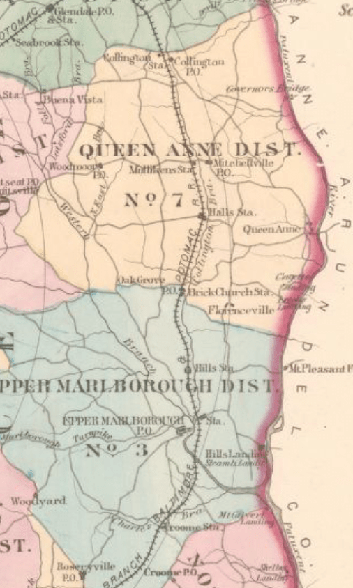
Washington and his family were recorded in Marlboro District; the location of their home can be approximated by comparing the names of their neighbors with the Hopkins’ Map of 1878. They did not live very far from their 1870 home which was northwest of Oak Grove in Queen Anne’s district.

A review of the page immediately preceding and following Washington Lee’s record shows that they lived near town. There are at least three carpenters, a bricklayer, storekeeper and hotel keeper listed among the occupation.
Geo. W Brooke and Upton Brooke are listed on the next page. They can be identified on the Marlboro District detail map from Hopkin’s Atlas as being near the Oak Grove Post Office and Brick Church Station. St. Barnabas Episcopal Church was well known for its brick construction and the station on the railroad was later renamed Leeland. It is at the intersection of the modern roads Oak Grove Rd and Leeland Road.
Hopkins created an Atlas of the fifteen miles around Washington DC including the County of Prince George, Maryland in 1878, which also lists landowners.
1900-1910 Community Context
In the margin of the 1910 Census is written Governor’s Bridge to Queen Anne, which suggests that the Lee family lived near the Patuxent river between Governor’s Bridge to the north and Queen Anne’s Bridge to the south.

The Paul Sharps family is a relative neighbor of the Lee family in both the 1900 and 1910 census. In 1900, Paul Sharps is listed on page 22 of the census, while the Lee family is listed on page 25. In 1910, Paul Sharps is on the same page as the Lee family.
Washington Lee is listed as the owner of the land in the 1910 Census, while Paul Sharps rents the land he is working.
The Selman family is listed on page 26. There are two Sellman families located near Governor’s Bridge on the 1878 map of District 1 of Anne Arundel. This suggests that the Lee family lived closer to Governor’s Bridge than to Queen Anne.
This area is roughly southeast of the modern day exchange of US Highways 301 and 50.
In both census records, the Parker family has numerous households in close proximity to the Lee family, prompting the research question if they are connected.
Further Research Needed:
- What connections exist between the Parker family and the Lee family?
- What records exist corroborate the census record that Washington Lee owned his property in 1910?
- Where did the children live in the 1900 census?


