Martha Reeder | Freedman’s Bureau

Known Information

Thomas and Martha Reeder were living in DC during the 1870 census.

Sources

Print

Taylor, James E., Artist. Glimpses at the Freedmen’s Bureau. Issuing rations to the old and sick / from a sketch by our special artist, Jas. E. Taylor. Richmond Virginia, 1866. Photograph. https://www.loc.gov/item/2009633700/

Freedman’s Village, Arlington i.e., Alexandria, Va. United States Arlington Alexandria Virginia, None. [Photographed between 1861 and 1865, printed between 1880 and 1889] Photograph. https://www.loc.gov/item/2014645761/

Map

Boschke, A, D McClelland, Hugh B Sweeny, Thos Blagden, and Blanchard & Mohun D. Mcclelland. Topographical map of the District of Columbia. Washington: D. McClelland, Blanchard & Mohun, 1861. Map. https://www.loc.gov/item/88694013/

United States, Freedmen’s Bureau Ration Records,1865-1872

District of Columbia, United States, NARA microfilm publications M1055. Records of the Bureau of Refugees, Freedmen, and Abandoned Lands, 1861 – 1880, RG 105. (Washington, D.C.: National Archives and Records Administration, 1969-1980); roll 16 | familysearch.org

Newspapers

The Baltimore Sun 
Baltimore, Maryland
14 Jan 1868, Tue  •  Page 4

The Freedman’s Bureau was a US government agency from 1865-1872 charged with directing provisions, clothing, fuel “for the immediate and temporary shelter and supply of destitute and suffering refugees and freedmen and their wives and children”

The Bureau kept records of what provisions, or rations were distributed.

In 1868, they recorded that Martha Reeder was provided $2.00 worth of groceries as she was unemployed. They listed her residence as Kendall Green. In addition to Martha, Cora Reeder was also recorded as residing at Kendall Green and receiving rations due to sickness.

This sketch is of a Richmond Bureau Office distributing rations “to the old and sick”

Kendall Green

After the Civil War, the US Government converted military barracks into housing for freepeople. Kendall Green Barracks, located on the northeast boundary of the city was one of the converted barracks. Kendall Green was located along Boundary Ave, in the northeast quadrant of the city. On the map, it is directly “north” of the capitol building, between Delaware and Maryland Avenues. The northern edge of the camp was at M and Boundary Ave.

In 1867, Kendall Green became the housing for the freed people who were unable to pay their rent and the Freedmen’s Bureau began to transfer nonpaying tenants and “those that pay very irregularly” to Kendall Green and those who could pay to housing closer to the city. In a newspaper article, the barracks are described a light one-story frame tenements with twenty-one rooms, housing 250 freedpeople.

Picture of the school established at Freedmen’s Village in Alexandria, VA

These barracks have been fitted up for dwellings for the freed people to be rented for very low rates, in order to get them out of the wretched shanties in which such numbers of them have hitherto lived (and died). But they are located so far from one side of the city, that they are taken up slowly.

Letter from A. E. Newton reporting on the school built near Kendall Green Barracks as listed in the National Freedman, A Monthly Journal, Vol 11, No 5 May 1866 (147)

Further Research Needed:

  • Determine the relationship between Martha and Cora Reeder
  • Identify other Reeders recorded in the Freedmen’s Records
related posts

Thomas Reeder | Jackson alley

Known Information

Thomas Reeder lived in DC after the Civil War.

Sources

Newspapers

Evening Star 
Washington, District of Columbia
23 Jul 1866, Mon  •  Page 2

Evening Star 
Washington, District of Columbia
13 Jul 1867, Sat  •  Page 3

Evening Star 
Washington, District of Columbia
27 Jul 1867, Sat  •  Page 3

Evening Star 
Washington, District of Columbia
26 Sep 1867, Thu  •  Page 3

Evening Star 
Washington, District of Columbia
07 Jun 1873, Sat  •  Page 4

Evening Star 
Washington, District of Columbia
24 Dec 1877, Mon  •  Page 2

Map

Gamble, W. H, and S. Augustus Mitchell. Plan of the city of Washington: the capitol sic of the United States of America. [Philadelphia: S. Augustus Mitchell Jr, 1869] Map. https://www.loc.gov/item/88693479/

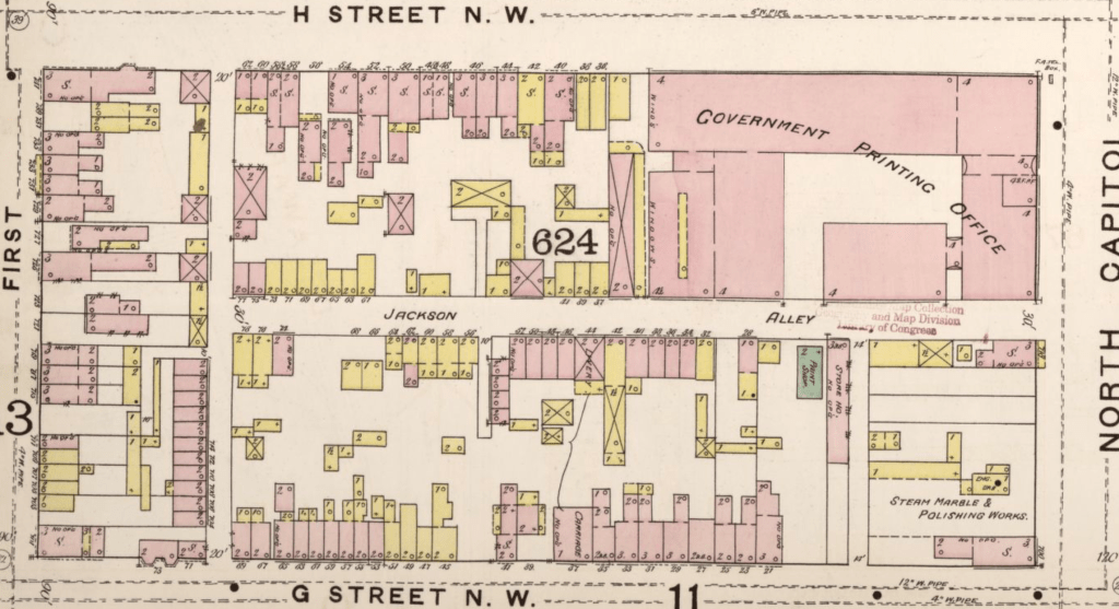
Sanborn Fire Insurance Map from Washington, District of Columbia, District of Columbia. Sanborn Map Company, 1888. Map. https://www.loc.gov/item/sanborn01227_001/.

City Directory

Washington, District of Columbia, City Directory, 1864

Print

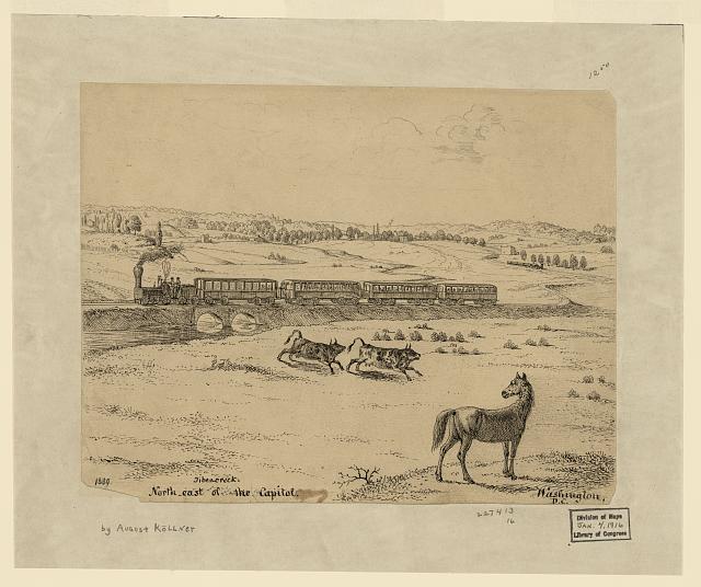
Kollner, Augustus, Artist. Tiber Creek north-east of the Capitol. Washington, D.C. Washington D.C. United States Tiber Creek, 1839. Photograph. https://www.loc.gov/item/2004662005/

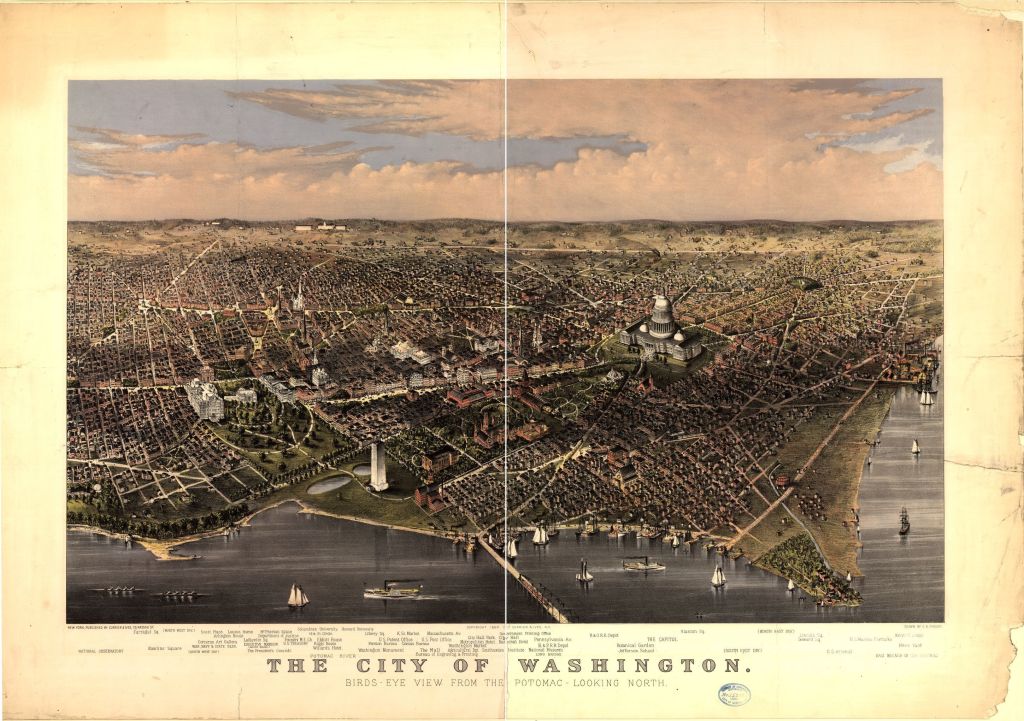
Currier & Ives, Publisher, and Charles R Parsons. The City of Washington birds-eye view from the Potomac-looking north / drawn by C.R. Parsons. United States Washington D.C. District of Columbia Washington, ca. 1880. New York: Published by Currier & Ives. Photograph. https://www.loc.gov/item/90716011/

Swampoodle

The Tiber Creek ran northeast of the Capitol, no longer a contained canal. When there were storms, the creek often flooded, washing away bridges and filling basements. Due to the swampy nature of this floodplain and the left behind puddles, the area near the Union Pr. Office was called Swampoodle.

In this rendering of Washington, Massachusetts Ave intersects with North Capitol Street near the center seam of the picture. The blocks north of this intersection was called Swampoodle and contained Jackson Alley.

Jackson Alley was considered the heart of Swampoodle, and ran between G and H street, along the Printing Office. Originally an Irish enclave, when refugees from slavery arrived in the City of Washington during the Civil War, African-American families also found homes in Swampoodle.

1880 Census

In the 1880 Census, Thomas Reeder was recorded living with his family with Robert Childs and his family in 71 Jackson Alley. Thomas and his wife Martha had three children: Mary E, 10, Joseph, 8, and Georgiana, 4. Thomas and his wife, Martha, were born in Maryland while their children were all born in DC.

Mary E. is marked as having attended school.

The City Directories for 1883-1901 show Thomas living at various addresses in Jackson Alley; sometimes at #65, or #50, or #34. The variety of house numbers suggests that the Reeder family shifted as rent prices and space shifted in the alley. The excerpt from the Sanborn Fire Insurance maps shows the variation in size and that some homes were frame and some were brick. The end of the block near the Printing Office was more industrial in nature, containing a livery station, a factory and storehouse.

Further Research Needed:

  • Locate residences in earlier censuses

related posts