The 1910-1920 Census lists the place of residence for George and Mary Wedge as near Upper Marlboro, MD. Their death certificates list their place of residence as Browns, MD
Sources
1930 Census
1930; Census Place: Mellwood, Prince George, Maryland; Page: 2B | ancestry.com
Benjamin Wedge was born in 1888; he was one of the younger sons of George and Mary Elizabeth Wedge. In 1910, he is recorded living in his parents’ household, age 22 and already widowed. He has his own young son, that he named after himself, age 1. By 1920, he has remarried; He, his wife, Julia, and his son, Benjamin are living with his parents. Both the 1910 and the 1920 household are located near Upper Marlboro, MD.
In 1925, Benjamin was the informant for his mother’s death certificate. The place of residence was lists as Browns, MD. Browns is a small farming town northeast of Upper Marlboro and its own distinct community from Upper Marlboro. George Wedge, who died in 1924, died as a result of a kick to the head by a horse.
1930 Census
In 1930, Ben is in Browns Md. The size of the community appears to be small as the census enumerator specifically wrote the name of town next to the entries. Five families are listed on page 1B; four families are listed on page 2A and two on page 2B, for a total of 11 families. Robert Brown owns land worth $10,000 and William Marr owns land worth $5,000. Eight of the families rented their farms. Wedge’s monthly rent was $400, which when compared to the other Black tenant farmers suggested he worked a larger parcel of land, as some of the families’ rent were $100 and 150. It was still small compared to the white tenant farmers whose rent was $3,000 and $1500.
George Washington Wedge and Mary Elizabeth Sharps were married in 1872 and raised their family in and around Queen Anne’s District of Prince George’s County, Maryland
Sources
1880 Census
1880; Census Place: Marlboro, Prince George’, Maryland; Roll: 513;Page: 73B | ancestry.com
1900 Census
1900; Census Place: Queen Anne, Prince George, Maryland; Page: 3;Enumeration District: 0098 | ancestry.com
1910 Census
1910; Census Place: Election District 3, Prince George’s, Maryland; Roll: T624_567; Page: 7B| ancestry.com
1920 Census
1920; Census Place: Marlboro, Prince Georges, Maryland; Roll: T625_674;Page: 4A| ancestry.com
The table summarizes the household of George and Mary Wedge from 1880-1920. The 1890 Census was burned in a fire and generally unavailable. The individuals and their ages are recorded in the table.
Note on census locations
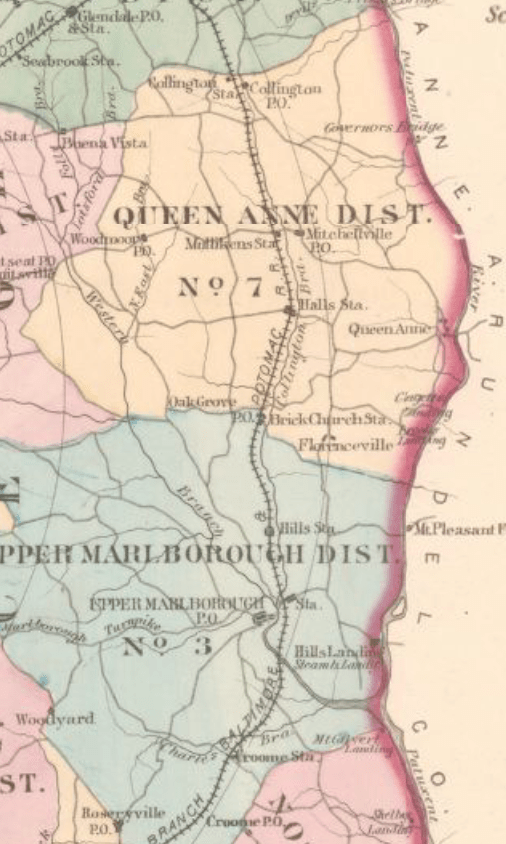
Marlboro District is located directly south of Queen Anne’s District within Prince George’s County.
Excerpt from Hopkins Map of 1878
Name
1880 Marlboro District, PG
1900 Queen Anne, PG
1910 District 3, PG (Marlboro)
1920 Marlboro, PG
George (Washington)
35
60
60
75
Lizzie
28
55 (10 children, 6 living)
55 (10 children, 6 living)
70
Edward/Eddie J
5
24
George W/Willie
1
21
Martha
16
35
Robert
15
Bennie
12
22
29
Ernest
10
Mary, (grand)mother
60
80
John, brother
21
40
Mary, sister
16
Berry Young, grandson
13
Benjamin, grandson
1
10
Julia, daughter in law
24
Robert Asbery, lodger
20
William Brice, lodger
35
1880 Census | Community Context
Scanning names on either side of the 1880 census listing for George Wedge allows the identification of neighbors, which used in conjunction with landowner maps provides an approximate location for their residence.
The white text on the map excerpt indicate the individual’s dwelling number and page in the 1880 Census. Mordecai Plummer and Wm. B Hill were large white landowners. Walter Harrison and John Quander were Black landowners.
Plummer owned a large tract of land called “Spring Hill” that was partitioned in 1873 with some land being given to his daughter and her husband John Bowling. Henry W. Clagett, the nephew of Plummer, is listed south of the Mount Pleasant Ferry Road.
George Wedge was on page 73B, which suggest that the family lived slightly north of the Quander and Harrison house and on the east side of the road to Florenceville.
George and his family members, as well as his neighbors are listed as laborers, while Plummer and Hill are listed as farmers. In 1875, John Henry Quander purchased an acre from Clagett and worked a tenant farmer for John Bowling according to the Maryland Historical Trust Maryland Inventory of Historic Properties Form for his home. This suggests that George Wedge and his neighbors worked on the Plummer, Bowling, and Clagett properties, as well, as tenant farmers after the Civil War.
1910 Community Context
In 1910, George Wedge is listed on page 7b as John W Wedge. His wife, Lizzie, and son, Benjamin, are consistent with previous records, as is his middle initial, suggesting it was an error on the part of the census enumerator, recording John instead of George.
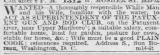
Their two neighbors, James Ireland and Benjamin Galloway, have the phrase “club house” listed in the notes about their occupation and in the margin of the Census page is written, “Marlborough Hills Landing Road”. This is the road on the east side Upper Marlborough that leads from Chas. Ridgeley past Wm. B Hill’s residence to a store and Boat Landing on the 1878 Hopkins Map.
The club house most likely refers to the Marlboro Hunt Club, which began in 1880. It operated as a sportsman’s club, with president’s like FDR and Teddy Roosevelt visiting. It was called the Patuxent Gun and Rod Club in the early 1900s.
Baltimore Sun, 15 Mar 1899, p. 3
On the preceding page is the record for Reverdy Sasscer. According to the documentation included in the application for House at Hills Landing to be Maryland Historic Property, the Anne Brooke, the daughter of Wm Hill, conveyed the property to Sasscer in 1901. The address given is 5802 Green Landing Road, very near to the location of the Marlboro Hunt Club.
This suggests that George Wedge and his family were living in the Hill’s Landing Community, working as a tenant farmer on the lands that historically have been owned by the Hill family.
1920 Community Context
In 1920, George Wedge is listed on page 4A. In the margins of the page, the enumerator lists North Side of Marlborough to Wells Corner Road, and the locality at the top is listed as outside town limits.
“Sugar Hill” was the name of a small African-American community that lived outside of Upper Marlboro, near the railroad lines. It had been established when several African-Americans labored on the Baltimore and Potomac Railroad after the Civil War. (Approved Historic Sites and Districts Plan) On page 3B, several of the residents are laborers for the Steam Railroad, suggesting that the Wedge family lived in vicinity of the Sugar Hill neighborhood.
George Wedge is the neighbor of Robert L Hall who married the granddaughter of Mordecai Plummer. Hall’s son was a businessman at the tobacco market, also located in vicinity of Sugar Hill.
Further Research Needed:
Locate records that better identify possible locations in Queen Anne’s District for the 1900 census.
George W Wedge died on 11 October 1924 and lived near Browns, Md. Mary Elizabeth Wedge died 25 April 1925 and lived near Browns, MD
Sources
Death Certificates
Department of Health Bureau of Vital Statistics (Death Record, Counties) Prince George’s County, [MSA SE43-3797] and [MSA SE43-3828] | Maryland State Archives
Record
1920; Census Place: Marlboro, Prince Georges, Maryland; Roll: T625_674;Page: 4A | ancestry.com
Both George and Mary Wedge had the village or city of Browns listed on their death certificate as their place of residence. Browns was a small farming community northwest of Upper Marlboro in the Marlborough District of Prince George’s County. It was located at the intersection of Brown Road and Browns Station Road, north of Cabin Branch. It is also near a community called Westphalia. The area is immediately southwest of Oak Grove.
Railway Station
Inside of Chesapeake Beach Railway Time Table for 1904, Smithsonian Institution Archives, RU 007181, Box 2, Folder 9, Image Number SIA2015-002378. | Smithsonian Archives
RU 007181, Box 2, Folder 9;
A station was build near where Brown’s store was indicated on the map when the Chesapeake Beach Railway was built shortly before the turn of the century. The railway brought tourists to Chesapeake Beach until the Great Depression when it wasn’t financially viable anymore.
The cluster of names around Benj H Brown with the store shows the location of Browns, Maryland. Westphalia is immediately to the west where the School House and Grave Yard are indicated. Brown appears to have operated the store as evidenced by advertisements run in the local newspaper.
The Prince George’s Enquirer and Southern Maryland Advertiser, 24 Apr 1896, page 2 | newspapers.comWashington Times, 12 Aug 1909, page 9 newspapers.com
Further Research Needed:
Compare this residence with residences in the censuses