George Wedge and Mary Sharps

Over the decades through census records

Known Information

George Washington Wedge and Mary Elizabeth Sharps were married in 1872 and raised their family in and around Queen Anne’s District of Prince George’s County, Maryland

Sources

1880 Census

1880; Census Place: Marlboro, Prince George’, Maryland; Roll: 513;Page: 73B | ancestry.com

1900 Census

1900; Census Place: Queen Anne, Prince George, Maryland; Page: 3;Enumeration District: 0098 | ancestry.com

1910 Census

1910; Census Place: Election District 3, Prince George’s, Maryland; Roll: T624_567; Page: 7B | ancestry.com

1920 Census

1920; Census Place: Marlboro, Prince Georges, Maryland; Roll: T625_674;Page: 4A | ancestry.com

The table summarizes the household of George and Mary Wedge from 1880-1920. The 1890 Census was burned in a fire and generally unavailable. The individuals and their ages are recorded in the table.

Note on census locations

Marlboro District is located directly south of Queen Anne’s District within Prince George’s County.

Excerpt from Hopkins Map of 1878

Name1880
Marlboro District, PG
1900
Queen Anne, PG
1910
District 3, PG (Marlboro)
1920
Marlboro, PG
George (Washington)35606075
Lizzie2855
(10 children, 6 living)
55 (10 children, 6 living)70
Edward/Eddie J524
George W/Willie121
Martha1635
Robert15
Bennie122229
Ernest10
Mary, (grand)mother6080
John, brother2140
Mary, sister16
Berry Young, grandson13
Benjamin, grandson110
Julia, daughter in law24
Robert Asbery, lodger20
William Brice, lodger35

1880 Census | Community Context

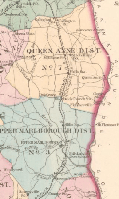
Scanning names on either side of the 1880 census listing for George Wedge allows the identification of neighbors, which used in conjunction with landowner maps provides an approximate location for their residence.

Hopkins, Griffith Morgan, Jr. Atlas of fifteen miles around Washington, including the County of Prince George, Maryland. Philadelphia: G.M. Hopkins, 1878.

The white text on the map excerpt indicate the individual’s dwelling number and page in the 1880 Census. Mordecai Plummer and Wm. B Hill were large white landowners. Walter Harrison and John Quander were Black landowners.

Plummer owned a large tract of land called “Spring Hill” that was partitioned in 1873 with some land being given to his daughter and her husband John Bowling. Henry W. Clagett, the nephew of Plummer, is listed south of the Mount Pleasant Ferry Road.

George Wedge was on page 73B, which suggest that the family lived slightly north of the Quander and Harrison house and on the east side of the road to Florenceville.

George and his family members, as well as his neighbors are listed as laborers, while Plummer and Hill are listed as farmers. In 1875, John Henry Quander purchased an acre from Clagett and worked a tenant farmer for John Bowling according to the Maryland Historical Trust Maryland Inventory of Historic Properties Form for his home. This suggests that George Wedge and his neighbors worked on the Plummer, Bowling, and Clagett properties, as well, as tenant farmers after the Civil War.

1910 Community Context

In 1910, George Wedge is listed on page 7b as John W Wedge. His wife, Lizzie, and son, Benjamin, are consistent with previous records, as is his middle initial, suggesting it was an error on the part of the census enumerator, recording John instead of George.

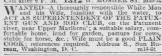
Their two neighbors, James Ireland and Benjamin Galloway, have the phrase “club house” listed in the notes about their occupation and in the margin of the Census page is written, “Marlborough Hills Landing Road”. This is the road on the east side Upper Marlborough that leads from Chas. Ridgeley past Wm. B Hill’s residence to a store and Boat Landing on the 1878 Hopkins Map.

The club house most likely refers to the Marlboro Hunt Club, which began in 1880. It operated as a sportsman’s club, with president’s like FDR and Teddy Roosevelt visiting. It was called the Patuxent Gun and Rod Club in the early 1900s.

Baltimore Sun, 15 Mar 1899, p. 3

On the preceding page is the record for Reverdy Sasscer. According to the documentation included in the application for House at Hills Landing to be Maryland Historic Property, the Anne Brooke, the daughter of Wm Hill, conveyed the property to Sasscer in 1901. The address given is 5802 Green Landing Road, very near to the location of the Marlboro Hunt Club.

This suggests that George Wedge and his family were living in the Hill’s Landing Community, working as a tenant farmer on the lands that historically have been owned by the Hill family.

1920 Community Context

In 1920, George Wedge is listed on page 4A. In the margins of the page, the enumerator lists North Side of Marlborough to Wells Corner Road, and the locality at the top is listed as outside town limits.

“Sugar Hill” was the name of a small African-American community that lived outside of Upper Marlboro, near the railroad lines. It had been established when several African-Americans labored on the Baltimore and Potomac Railroad after the Civil War. (Approved Historic Sites and Districts Plan) On page 3B, several of the residents are laborers for the Steam Railroad, suggesting that the Wedge family lived in vicinity of the Sugar Hill neighborhood.

George Wedge is the neighbor of Robert L Hall who married the granddaughter of Mordecai Plummer. Hall’s son was a businessman at the tobacco market, also located in vicinity of Sugar Hill.

Further Research Needed:

  • Locate records that better identify possible locations in Queen Anne’s District for the 1900 census.

George and Mary Wedge | Browns, MD

Known Information

George W Wedge died on 11 October 1924 and lived near Browns, Md. Mary Elizabeth Wedge died 25 April 1925 and lived near Browns, MD

Sources

Death Certificates

Department of Health Bureau of Vital Statistics (Death Record, Counties) Prince George’s County, [MSA SE43-3797] and [MSA SE43-3828] | Maryland State Archives

Record

1920; Census Place: Marlboro, Prince Georges, Maryland; Roll: T625_674;Page: 4A | ancestry.com

Both George and Mary Wedge had the village or city of Browns listed on their death certificate as their place of residence. Browns was a small farming community northwest of Upper Marlboro in the Marlborough District of Prince George’s County. It was located at the intersection of Brown Road and Browns Station Road, north of Cabin Branch. It is also near a community called Westphalia. The area is immediately southwest of Oak Grove.

Railway Station

Inside of Chesapeake Beach Railway Time Table for 1904, Smithsonian Institution Archives, RU 007181, Box 2, Folder 9, Image Number SIA2015-002378.
| Smithsonian Archives

RU 007181, Box 2, Folder 9;

A station was build near where Brown’s store was indicated on the map when the Chesapeake Beach Railway was built shortly before the turn of the century. The railway brought tourists to Chesapeake Beach until the Great Depression when it wasn’t financially viable anymore.

Hopkins, Griffith Morgan, Jr. Atlas of fifteen miles around Washington, including the County of Prince George, Maryland. Philadelphia: G.M. Hopkins, 1878.

Farming Community

The cluster of names around Benj H Brown with the store shows the location of Browns, Maryland. Westphalia is immediately to the west where the School House and Grave Yard are indicated. Brown appears to have operated the store as evidenced by advertisements run in the local newspaper.

The Prince George’s Enquirer and Southern Maryland Advertiser, 24 Apr 1896, page 2 | newspapers.com
Washington Times, 12 Aug 1909, page 9
newspapers.com

Further Research Needed:

  • Compare this residence with residences in the censuses

related posts

James Edward Wedge | steel worker

Known Information

James Edward Wedge moved to DC shortly after the turn of the century in the early 1900s.

Sources

Draft Registration Card

U.S., World War I Draft Registration Cards, 1917-1918 | ancestry.com

Summary Statement

James Wedge registered for the draft during World War I. His birth year was listed as 1875, compared to 1881 on his death certificate.

He listed his mother, Elizabeth Wedge, as a near relative and that she lived in Marlboro, MD. He was of medium height and medium build.

His home address is consistent with the address given on his death certificate and listed in the obituary.

Giesboro Point | Steel Manufacturing

Giesboro Point is located across the Anacostia River where it joins the Potomac River. The location is now part of the Joint Base Anacostia-Bolling. The government rented the land during the Civil War, where it served as a Calvary Depot. Prior to World War I, the land was purchased by the the Firth Sterling Steel company and they established a steel plant with railroad lines to manufacture munitions. It became the Washington Steel and Ordnance in 1911 and was dissolved in 1921 after the war when demand for munitions ended.

Washington Times, 17 March 1907, pg 13 newspapers.com
Washington Times, 12 May 1907, p 44
Washington Times, 28 Apr 1917

World War I

During World War I, it employed thousands of men in the DC area to meet the need for munitions. It paid $2 a day for unskilled labor in order to hire laborers when immigration quota and the armed forces’ recruitment of men shrunk the labor pool.

Evening Star, 15 Dec 1918, p 40

Further Research Needed:

  • The document lists his mother as Elizabeth Wedge and connects James Wedge with the Wedge family in Marlboro, Prince George’s County. What other connections between the family can be established.

related posts

Washington Lee and Sallie Stewart

Over the decades through census records

Known Information

Washington Lee & Sallie Stewart were married in 1870 and raised their family in and around Queen Anne’s District of Prince George’s County, Maryland

Sources

1880 Census

1880; Census Place: Marlboro, Prince George’s, Maryland; Roll: 513;Page: 75B | ancestry.com

1900 Census

1900; Census Place: Election District 1, Anne Arundel, Maryland; Page: 25 | ancestry.com

1910 Census

1910; Census Place: Election District 1, Anne Arundel, Maryland; Roll: T624_550; Page: 12A | ancestry.com

The slideshow has the records for Washington and Sallies family from 1880, 1900 and 1910. The 1890 Census was burned in a fire and generally unavailable. The individuals and their ages are recorded in the table.

Note on census locations

Marlboro District is located directly south of Queen Anne’s District within Prince George’s County.

District 1 is located in the western part of Anne Arundel County, opposite Queen Anne’s District in Prince George’s County

Excerpt from Hopkins Map of 1878

Name1880
Marlboro District, PG
1900
District 1, AA
1910
District 1, AA
Washington Lee406073
Sallie356070
12 Children Born
8 Children still living
Jane7
Susan6
Benjamin5
Sallie3
Peterinfant
Lizzie2
Catherine14
Rosa10
Louisa7
Edwardgrandson, 3

1880 Census | Community Context

Washington and his family were recorded in Marlboro District; the location of their home can be approximated by comparing the names of their neighbors with the Hopkins’ Map of 1878. They did not live very far from their 1870 home which was northwest of Oak Grove in Queen Anne’s district.

A review of the page immediately preceding and following Washington Lee’s record shows that they lived near town. There are at least three carpenters, a bricklayer, storekeeper and hotel keeper listed among the occupation.

Geo. W Brooke and Upton Brooke are listed on the next page. They can be identified on the Marlboro District detail map from Hopkin’s Atlas as being near the Oak Grove Post Office and Brick Church Station. St. Barnabas Episcopal Church was well known for its brick construction and the station on the railroad was later renamed Leeland. It is at the intersection of the modern roads Oak Grove Rd and Leeland Road.

Hopkins created an Atlas of the fifteen miles around Washington DC including the County of Prince George, Maryland in 1878, which also lists landowners.

Hopkins, Griffith Morgan, Jr. Atlas of fifteen miles around Washington, including the County of Prince George, Maryland. Philadelphia: G.M. Hopkins, 1878.

1900-1910 Community Context

In the margin of the 1910 Census is written Governor’s Bridge to Queen Anne, which suggests that the Lee family lived near the Patuxent river between Governor’s Bridge to the north and Queen Anne’s Bridge to the south.

The Paul Sharps family is a relative neighbor of the Lee family in both the 1900 and 1910 census. In 1900, Paul Sharps is listed on page 22 of the census, while the Lee family is listed on page 25. In 1910, Paul Sharps is on the same page as the Lee family.

Washington Lee is listed as the owner of the land in the 1910 Census, while Paul Sharps rents the land he is working.

The Selman family is listed on page 26. There are two Sellman families located near Governor’s Bridge on the 1878 map of District 1 of Anne Arundel. This suggests that the Lee family lived closer to Governor’s Bridge than to Queen Anne.

This area is roughly southeast of the modern day exchange of US Highways 301 and 50.

In both census records, the Parker family has numerous households in close proximity to the Lee family, prompting the research question if they are connected.

Hopkins, Griffith Morgan, Jr. Atlas of fifteen miles around Baltimore, including Anne Arundel County, Maryland. Philadelphia, 1878. Map. 

Further Research Needed:

  • What connections exist between the Parker family and the Lee family?
  • What records exist corroborate the census record that Washington Lee owned his property in 1910?
  • Where did the children live in the 1900 census?