Charles Graham


1852-1902

In 1862, the District of Columbia emancipated the individuals enslaved within its borders; it also offered reparations to the enslavers, who could no longer force labor from the freed.

George Washington Young submitted a list of the people he enslaved so as to be compensated. Among the names is the family group of Grahams: Peter and Charity Graham and their children, including Charley Graham, age 9. His height was listed as 4 foot 8 inches. He was of average height for his age.


Young owned a considerable amount of land in Anacostia. He managed two plantations: Nonesuch and Giesborough Manor, both across the river in the area considered Anacostia today. Nonesuch was located north of Good Hope, in a neighborhood now called Hillcrest. His grandfather, Notley Young, had owned plantations in what became the city of Washington, particularly Duddington Pasture, which was located on the southwest waterfront.

View, probably 1833, from Anacostia, showing Navy Yard and Capitol in center | painted by G. Cooke ; engd. by W.J. Bennett. | loc.gov

G. W. Young purchased Giesborough Manor in 1833 and inherited Nonesuch from his father in 1826. In addition to inheriting the land, his father also named several enslaved individuals, among them, Peter and Charity, Charley’s parents in the 1862 emancipation records, in his bequest for George Washington Young.

Peter worked both as field hand and blacksmith. Charity was a field hand. Likely, Charles worked beside his parents in the fields.


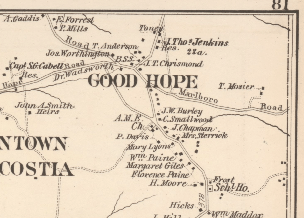
In 1870, the Grahams are living near Good Hope (DN 910). The Census records Charity, as a white washer, with her children and Johanna Chase. Charles is working as a farm laborer. Their neighbors are the Paine and Giles household visible on the Hopkins Map, south of Good Hope.

His brother, Robert Graham, is living nearby with his own household, also working as a farm laborer (DN 929). Robert is a neighbor of Jos. Worthington who is shown on the Hopkins 1878 map of Good Hope. GWJ Hatton, a blacksmith, lives in the Robert Graham household. Thomas Anderson (1792-1882) was a blacksmith as well, and grew produce he sold at Center Market. (East of the River) Anderson’s daughter married Jerome Hutton in 1871.

Excerpt from Hopkins Map | loc.gov

In 1875, Charles Graham and Johanna Chase applied for a marriage license. Two death records: one for an infant girl and one for Johanna Graham show that she died giving birth in Mar 1877.

Johanna Chase is listed in the 1870 Household of Charles’ mother, Charity. She may be the same Johanna Graham that is listed in the family group of Peter and Charity in the emancipation records of George Washington Young. She is listed in the census as 25 with an estimated birth year of 1845.

Her birthplace, unlike the Graham’s, is listed as Maryland. There are Chase households in Hyattsville, Collington and Upper Marlboro in Prince George’s County in the 1870 Census. It is possible that she connected to these.

In the 1880 Census, Charles is still living with Charity and several of her grandchildren: Mary, Sally, Robert and Edward. It is unclear if the four children listed in Charity’s household are the children of Charles and Johanna. Edward, the youngest, if age 4, suggesting that they were all born prior to 1877.


In 1881, Charles married Alice Dent, a widow with three children, Charles, Georgiana, and William.

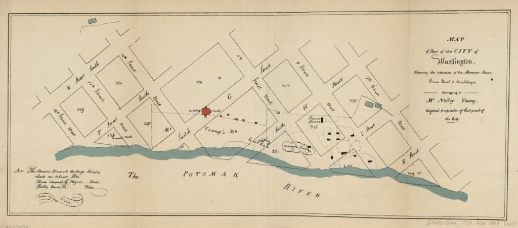
Alice’s first father-in-law, Bruce Dent had been a huckster at Centre Market, and was able to purchase land on Bowen Road, near the plantation of Nonesuch. Dent’s second wife continued to be a huckster, while he was a gardener. The map excerpt shows Good Hope on the left, and Bowen road leading northeast to the lands of Nonesuch. (Mary B Denham and Washington A Young were heirs of G. W. Young.). To the right of the Denham and Young land are small parcels. Dent owned 5 acres on the MD border; in 1875, he was delinquent on his taxes and the land description was included in the National Republican: “Beginning at the intersection of the DC Lin with the boundary of IF Young’s part of ‘Nonesuch’ and the Trimble tract…”

Excerpt from Plate 44 of Hopkins Plat Book of DC } Washingtoniana Map Collection

Alice’s children, Charles, Georgiana and William list Anacostia and/or Oxon Hill as their birth place on records, suggesting that she had been living near Dent and therefore near the Grahams.


Charles’ brother, Robert Graham, moved to the City of Washington in the early 1870s, moving to B st se, near where Alice was working as a domestic servant in 1880.

In 1882, Charles is recorded living in Pleasant Alley, which is behind G street SW, two blocks south of where Bruce Dent had owned property on 3d Street between E and F. I

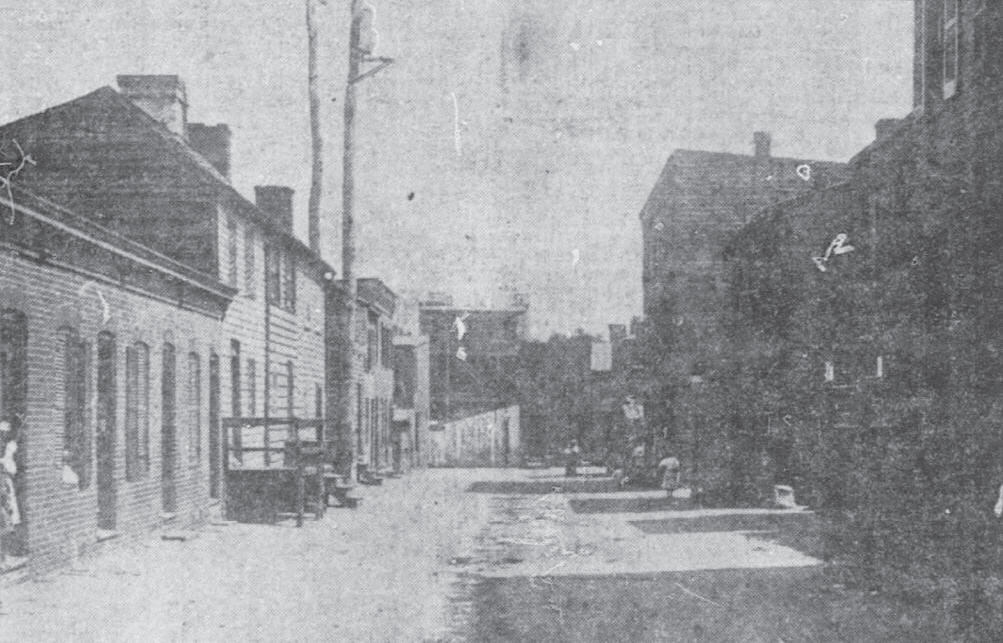
By 1886, the family had moved to southeast DC and Capitol Hill. Charles and his step-children are listed living at 301 G Street SE. In 1887, Georgiana married Frank Winters and moves to 427 2d SE. They are close to Eastern Market.

By 1900, Charles is living with his step-son, William Henry Graham at 303 7th St SE. He dies in 1902.

Maria Dent | Domestic

Known Information

In 1840, Susan Dent had two younger Free Black individuals living in her household. One was a female whose age is consistent with Maria Dent’s in the 1850 & 1860 Census.

Sources

Year: 1850; Census Place: Washington Ward 3, Washington, District of Columbia;Roll: 56; Page: 170a | ancestry.com

Year: 1860; Census Place: Washington Ward 3, Washington, District of Columbia; Page: 717 | ancestry.com

Evening Star | Washington, District of Columbia | 07 Jan 1862, Tue  •  Page 3

1853 City Directory of Washington DC | fold3.com

Maria Dent is listed in the household of J. S. Williams in both the 1850 and 1860 Census. No occupation is listed for her in either census.

1850 Census
1860 Census

J. S. Williams was a clerk with the Naval Department who lived on H Street between 9th and 10th. Born and married in Connecticut, he moved to DC in 1848 and died during the Civil War from Small Pox. His wife moved back to Connecticut after her husband’s death.

Though no occupation is listed for her, it is likely that Maria served as a domestic servant in the home. Williams’ property was valued at $3000 with personal property valued at $1000, suggesting means to hire Maria, a free Black. While the Williams and therefore Maria lived in Ward 3, “by 1860, one-eighth of the most prosperous families in the First Ward employed live-in servants, either white or black.” (Civil War Washington)

As a domestic in the household, it is possible that Maria’s work ranged across the spectrum of “women’s work”. Taking care of the Williams’ clothing alone would require sewing, washing, and ironing. Preparing meals may have meant cooking and serving.

In 1850, Maria is listed with a child, E., who is 7 years old. By the 1860 census, the child is no longer listed in the household. It is possible that the child by 1860 had either died, or had left the Williams household, apprenticed to another. The 1860 census does not enumerate an E Dent in other households, raising the likelihood of death. The Williams had a child, Thomas, who died in 1859 from consumption. It is possible that they both caught the same disease and passed away.

The 1870, 1873 and 1876 City Directories list a Maria Dent. In 1870, she was working as a cook in a nearby household, at 815 6th Street NW

Johnson Family | Thomas Hurdle, witness

Known Information

Susan and Isaac Johnson are the parents of Cassandra Johnson, the first wife of Bruce Dent.

Sources

Brown, L. W. (1972). Free Negroes in the District of Columbia, 1790-1846. New York: Oxford University Press.

Provine, D. S. (1996). District of Columbia free Negro registers, 1821-1861. Bowie, Md: Heritage Books.

City Directories for Washington, DC | Fold3

1820 U S Census; Census Place: Washington Ward 4, Washington, District of Columbia; Page: 103; NARA Roll: M33_5; Image: 110 | ancestry.com

Tanner, Henry Schenck. City of Washington. [Philadelphia: H.S. Tanner, 1836] | loc.gov

Susan and Isaac Johnson registered the free status of her two sons, Jacob and Charles Johnson, on 15 September 1827 in the District of Columbia. In this registration, Thomas Hurdle “swears that Isaac, [Sr.] and his wife, Susan, are by reputation free and that Jacob Johnson, aged about five, and Charles Johnson, aged about three, were born in his neighborhood and are the children of Isaac and Susan. They were born free.”

This affadavit, sworn on 13 Sept 1827, provides clues into the lives of the Johnson family in the District of Columbia.

Thomas Hurdle is listed in the 1822 and 1827 City Directory for Washington, District of Columbia. In the 1822 City Directory, he is listed as a foreman carpenter at the Capitol. The 1827 directory lists him as a carpenter living on 2e street near St. Joseph’s Church. In the 1820 Census, he is enumerated as living in Ward 4, which was around Capitol Square. Isaac Johnson is listed immediately prior to Thomas in the census.

Tanner, Henry Schenck. City of Washington. [Philadelphia: H.S. Tanner, 1836] | loc.gov

The neighborhood around the Capitol had two types of residents: congressmen and aides living in boarding houses, and the skilled laborers who were building the city after it was burned by the British in the War of 1812. The labor forced used by the city was a mix of Irish labor and Black labor, both free and enslaved.

1820 Census showing the neighborhood with a mix of free Black and white residents

Thomas Hurdle was listed as living near St. Joseph’s in the 1827 directory. The use of St. as part of the name suggests a Catholic Church, and the early maps of the City of Washington do not list a St. Joseph’s. Instead, I propose that the church referenced is St. Peter’s Church on 2nd and C street. This church was newly established in the 1820s, and both Black and white residents attended the church. St. Joseph’s, which is on 2nd Street in NE was not built until 1868. That the church was mislabeled in the Directory is strengthened by the 1830 Tax Lists.

The DC Tax Books record Archibald Johnson with property on block 734 and Isaac Johnson with property on block 733 in 1830. Between 1830 and 1845, Isaac’s taxes on the property went from $0.31 to $3.45 which suggests he made considerable improvements on his lot.

The small map overlay is a 1846 map showing blocks with buildings. #28 represents St. Peter’s Church. It is overlaid onto a 1840 map showing square numbers.
De Krafft, F. C, W. I Stone, and William M Morrison. Map of the city of Washington. [Washington, D.C.?: Wm. M. Morrison, 1840] 
Tanner, Henry Schenck, and S. Augustus Mitchell. City of Washington. [Philadelphia: S. Augustus Mitchell, 1846]
Library of Congress

During this time, the City of Washington was only 20 years old and transitioning from farmland to a city. Large parts of the city remained rural, and the homes of the residents were likely smaller ramshackle buildings.

Steel, James W., Engraver, and Thomas Doughty. The capitol Washington / drawn by T. Doughty ; eng. by J.W. Steel. Washington D.C, 1826. [Philadelphia: Published by A.R. Poole] | loc.gov

related posts

George R Dent | son of Bruce Dent

Known Information

George Dent is listed in the household of Bruce Dent in the 1860 census.

Newspaper Sources

Evening Star 
Washington, District of Columbia
27 Nov 1868, Fri  •  Page 4

National Republican 
Washington, District of Columbia
04 Dec 1868, Fri  •  Page 3

Evening Star 
Washington, District of Columbia
29 Jan 1869, Fri  •  Page 4

National Republican 
Washington, District of Columbia
30 Jan 1869, Sat  •  Page 4

Evening Star 
Washington, District of Columbia
25 May 1874, Mon  •  Page 4

Evening Star 
Washington, District of Columbia
24 Sep 1878, Tue  •  Page 4

Evening Star 
Washington, District of Columbia
10 Mar 1879, Mon  •  Page 4

National Republican 
Washington, District of Columbia
18 Nov 1879, Tue  •  Page 3

National Republican 
Washington, District of Columbia
02 Feb 1884, Sat  •  Page 6

Evening Star 
Washington, District of Columbia
18 Dec 1889, Wed  •  Page 10

The Critic 
Washington, District of Columbia
09 Oct 1890, Thu  •  Page 1

Evening Star 
Washington, District of Columbia
10 Oct 1890, Fri  •  Page 2

The Evening Times 
Washington, District of Columbia
13 Aug 1897, Fri  •  Page 5

The Evening Times 
Washington, District of Columbia
13 Aug 1897, Fri  •  Page 6

Evening Star 
Washington, District of Columbia
28 Sep 1901, Sat  •  Page 3

  • 1844-5 | Estimated Birth Year

    George was born in DC.

    Based on the 1850 & 1860 Census

  • 1850 | Residence in Ward 7 of Washington City

    He is living with his parents, Bruce and Cassandra Dent, in Ward 7 of DC.

    According to the census, George attended school, most likely founded by Enoch Ambush, who ran a school for Black children in southwest DC. Ambush ran a school at 10th and E Street. Additionaly, Ambush was a friend of Anthony Bowen who helped form one of the few schools for free blacks, the “Sunday Evening School”, in the Wesley Church, now the Metropolitan A.M.E.Z. Church on D Street SW.

    Based on the 1850 Census

  • 1860 | Residence in Ward 7 of Washington City

    He is living with his parents, Bruce and Cassandra Dent, in Ward 7 of DC. He is a teenager now, although no occupation is listed for him.

    Based on the 1860 Census

  • 1868-1869 | Arrest

    In Nov 1868, the Evening Star reports that “large crowd of colored population assembled near the Lincoln Barracks” to witness the laying of a cornerstone for “East Mission”, of Israel Methodist Episcopal Church. “There was considerable confusion and disturbance in the outskirts of the crowd during the evening confined principally to boys, and with that exception everything passed off quietly and peaceably.”

    In Dec 1868, the National Republican reports that George Dent was arrested on suspicious of participation in riot near Lincoln Barracks on Thanksgiving Day.

    In Jan 1869, the Evening Star reports that he was sentenced to three months in jail for resisting arrest. In the National Republican, it was reported that Geo Dent, Geo Poole, and Barney Clinkett were found guilty and Clinkett was sent to jail for 39 days for the riot, while Dent when away for three months for resisting arrest.

  • 1869 | Driver

    He is listed in the City Directory as a driver. He is living at the address that is consistent with Bruce Dent in the 1860s, 585 3d W.

  • 1870 | Residence in Ward 7

    George is living in the household of Silas and Fannie Greeley. Cyrus Greeley is listed in the 1871 City Directory as a cook living at 209 F SW. George is living about a block east of his father’s home on 3rd Street.

  • 1870s | Bricks

    In 1872, he is listed as a bricklayer at 513 3rd St SW. This is his father’s address, after DC updated the numbering system for addresses in 1869. In 1877, he is listed as bricklayer living in Willow Tree Alley, which is located between B and C and 3d and 4 1/2 SW.

    1910 Photograph of Willow Tree Alley as it appeared in the Washington Times | the alley was razed in 1913

  • 1874 | Affair & Arrest

    In May 1874, The Evening Start reported that Louisa Edelin, George Dent and Isabella Dent were arrested for assault and battery on John Edelin. The article reports that George Dent and Louisa Edelin (John’s wife) had been having an affair and when John found out, he addressed the trio. They assaulted him with paving stones. In Dec of 1874, George was fined $5 for his part in the assault.

  • 1878 | Arrest for Assault

    In Sept 1878, The Evening Start reported that George Dent, a hackman, was charged with assault and battery with intent to kill; he was arrested for a dispute over change from a newspaper that the boy was selling at the Baltimore and Potomac Railroad Depot. The Depot was located in Armory square, at 6th and B NW, immediately southeast of Center Market. The defense was able to show that the incident was an accident.

    Baltimore and Potomac Railroad Station | DC Public Library

  • 1879 | Profane Language and Vagrancy

    In 1879, George R. Dent was arrested twice, once for profane language, and for vagrancy for which he “was sent down to the farm.”

  • 1880 | Residence in Ward 7 of Washington City

    He is living in the household of Emma Johnson and Emma Walker, near Willow Tree Alley, on 4 and 1/2 Street. In 1882, the Critic reported that George pleaded guilty for assaulting Emma Walker and spent 7 days in jail.

    Based on the 1880 Census

  • 1884 | Soliciting fares

    In 1884, Geo. Dent was charged with soliciting hack fares in the Capitol Grounds, as reported in the National Republican.

  • 1889 | Disorderly Conduct

    In 1889, the Evening Star reported that “a small bald-headed” George Dent was charged with disorderly conduct at the Fisherman’s hall. The Order of Galilean Fisherman was a benevolent society established after the Civil War to help the newly emancipated Black people. It stressed equality and financial literacy. The map is an excerpt from Baist’s real estate atlas and shows square 538, where Bruce Dent held property in the 1850’s and 1860s. George lived in lots 26 of this square in the 1870. The Temple of Galillean Fisherman can be seen in the north half of square 539, off of F street.

  • 1890 | Fast driving

    In 1890, George Dent was accused of driving fast (faster than 8mph). He was a hackman who drove a Surrey and picked up fares at the Baltimore and Potomac Depot. A lawyer for Dent claimed that the animal could go that fast as he had driven him and was lame in one foot. The officer countered that the horse the lawyer had tested wasn’t the animal the Dent had driven. Dent was charged $5.

    Surrey, 1900; in the Suffolk Museum and Carriage House, Stony Brook, Long Island, N.Y. | Encyclopædia Britannica

  • 1897 | Accident at Brickmaker Factory

    The Evening times reported that George Dent fell from a kiln at Ford’s brickyard. He sustained a head injury and was taken to Providence Hospital.

  • 1900 | Residence in northeast DC | Schott’s Alley

    He is living in the household of Harry Hall. His occupation is listed as a hackman and his birth month is recorded as June.

    Based on the 1900 Census

  • 1901 | Death Reported

    His death is reported in the Evening Star.

Further Research Needed:

  • Locate his death certificate from DC Archives
  • Research connections between George Dent and the names reported with him in the articles

related posts

Bruce Dent | Nonesuch property

Known Information

Bruce Dent owned property in DC during the 1850s and 1860s. He is listed as living “East of Seventh Street” in the 1870 Census.

Sources

1870 Census

1870; Census Place: East of Seventh Street, Washington, District of Columbia; Roll: M593_127; Page: 726B

Map

Map of the District of Columbia including the cities of Washington, Georgetown, and Alexandria, Virginia. [Washington?: s.n, 1873] Map. https://www.loc.gov/item/88693472/.

A complete set of surveys and plats of properties in the city of Washington, District of Columbia, 1887, plate 44 | DC Library

Newspapers

National Republican 
Washington, District of Columbia
24 Jul 1875, Sat  •  Page 9

The Critic 
Washington, District of Columbia
19 Jan 1889, Sat  •  Page 17

Washington Times 
Washington, District of Columbia

20 Mar 1896, Fri  •  Page 3

Secondary Sources

Rural Remnants of Washington County: An Architectural Survey of Washington’s Historic Farms and Estates | DC Planning Commission

Anacostia Neighborhood Museum., & Hutchinson, L. D. (1977). Anacostia Story: 1608-1930. Washington: Smithsonian Institution Press.

East of the River: Continuity and Change by Portia James

Bruce Dent is listed as a farmer in the 1870 census; he is listed in the district “East of Seventh Street”, encompassing the large agricultural tracts beyond the city boundary. In the map, this district is reflected by the First District and eastern part of Second District. Seventh Street can be identified by the subdivision of Mt. Pleasant and Howard University.

Bruce Dent is listed in the National Republican for delinquent taxes for 5 acres of property in Nonesuch in 1875 (24 Jul 1875, p 9). His property borders I. M. Young’s property as well as the Trimble Tract.

Nonesuch

George Washington Young, the grandson of Notley Young, owned property across the Eastern Banch. He owned both Giesborough Manor and Nonesuch prior to the war. He inherited Nonesuch (both the mansion and the estate) in 1826 and purchased the Giesborough tract in 1833. The Nonesuch estate was along the Oxon Run watershed. Young had a house built for his daughter Mary upon her marriage to Col. Denman.

Hopkins, Griffith Morgan, Jr. Atlas of fifteen miles around Washington, including the County of Prince George, Maryland. Philadelphia: G.M. Hopkins, 1878.

The residence of both Young and Denmead can be seen on the southern part of this excerpt from Plate 77 of the Hopkins Map. It is along Bowen Road. Bruce Dent is also labeled along Bowen Road, his name on the right side of the road.

This corresponds with City Directories that lists him as living on Bowen Road, which was named for Sayles Jenk Bowen, elected mayor in 1868 and a staunch supporter of civil rights for Black people.

The excerpt from the 1887 Plat Book shows the size and relative location of the property along Bowen Road. In 1889, the Critic lists properties with assessed taxes, and includes his property, identifying it as plat 24, Nonsuch. (19 Jan 1889, page 17)

In 1896, The Washington Times reported that Bruce transferred 2 acres of the land to Benjamin Boyd.

Further Research Needed:

  • Locate the land records in the DC Archives
  • Identify Bruce Dent’s relationship to Benjamin Boyd

related posts

Bruce Dent | the Island property

Known Information

Bruce Dent is listed in the 1860 census with real estate valued at $750; he was a huckster who sold produce in the market.

Sources

Map

Tanner, Henry Schenck, and S. Augustus Mitchell. City of Washington. [Philadelphia: S. Augustus Mitchell, 1846] Map. https://www.loc.gov/item/88694050/

Keily, James, and Lloyd Van Derveer. Map of the city of Washington D.C.: established as the permanent seat of the government of the U.S. of Am. Camden, N.J.: Lloyd Van Derveer, 1851. Map. https://www.loc.gov/item/88694049/.

Tax Assessments

Appendix 3, p. 162 of Brown, L. W. (1972). Free negroes in the district of Columbia 1790-1846. New York U.P.

City Directory

Washington, District of Columbia, City Directory, 1864

The Island

Southwest DC was called the Island as a result of the Tiber Creek and James Canal which effectively cut it off from the rest of the City. Most of the land in southwest DC had been part of Notley Young’s plantation, which had been donated to the government for the city. James Greenleaf, a real estate speculator, purchased the land from the government in return for a promise to build ten new homes a year. He was unable to deliver that promise as he was unable to secure funds. The land, cut off by the canal, was slow to develop in the 1800s. It contained old plantations, industrial facilities and assortment of workmen’s homes. The southern most point was called Greenleaf Point.

King, N. Map of part of the city of Washington, shewing the situation of the mansion house, grave yard & buildings, belonging to Mr. Notley Young: original proprietor of that part of the city. [Washington, D.C.?: s.n., ?, 1796] Map. https://www.loc.gov/item/88693256/.

In 1845, Bruce Dent was listed in the District of Columbia Tax Records. He was assessed for property in square 499 at $1.50. The 1850 census listed his real estate valued $246

Square 499 was along 4 1/2 Street which was a thoroughfare through The Island. The map excerpt from 1851 shows how few improvements had been made to the lots in that part of DC, as more of the buildings and properties had been built closer to the Mall and near the wharves and Long Bridge. This suggests that the property in Square 499 had space that allowed for growing produce and/or raising livestock. the 1888 Sanborn Map of DC shows that the alley was named Cow Alley, recalling when livestock were kept here, perhaps.

Evening Star, 01 Oct 1857, p. 3

Bruce Dent first appears in the City Directories in 1858. His address is listed as 585 3rd West. He is listed at this address through the 1850s and 1860s until 1869. This is address corresponds to square 538. It is also along 4 1/2 street.

In 1867, Bruce Dent was listed among the delinquent tax assessments in the Evening Star (14 May 1867, p. 8). It lists three properties: square 538, lot 26 and improvements; square 582, part of lot 19 and improvements, as well as part of lot 20 and improvements. Square 538 from Baist’s Real Estate Atlas is included, showing lot 26 on the 3rd street side of the block about midpoint between E and F street.

Baist, G. Wm, Wm. E Baist, and H. V Baist. Baist’s real estate atlas of surveys of Washington, District of Columbia: complete in four volumes
. Philadelphia: G.W. Baist, -<1911 >, 1909. Map. https://www.loc.gov/item/87675120/. Plate 6

Further Research Needed:

  • Locate land records at the DC Archives for deed related to square 499, square 538, and square 582
  • Identify Bruce Dent’s residence after 1870

related posts

Bruce Dent | huckster

Known Information

Bruce Dent was listed as a huckster on the 1860 Census.

Sources

Quote about Market

Washington Times, 26 Mar 1922, p 16

Tax Assessments

The National Archives and Records Administration; Washington, D.C.; Internal Revenue Assessment Lists for the District of Columbia, 1862-1866

City Directory

Washington, District of Columbia, City Directory, 1864

The Seventh Street Market. United States Washington D.C, None. [Photographed between 1861 and 1865, printed between 1880 and 1889] Photograph. https://www.loc.gov/item/2013651861/

Although the canal which ran in front of the market was sluggish and unsightly in many respects, … Sailboats and small rowboats were constantly coming to the market bringing men and shining masses of fish. These fish had often been caught during the night and brought to the market at the dawn of the day to entice the busy housewife into the purchase of the delicious Potomac Shad, trout, bass, and other fish. Men in rubber coats stood on the banks of the canal quietly smoking their old brown pipes, while others stood by their stands encouraging the purchase of vegetables, fish or other products.

Centre Market

The Centre Market was located north of the Mall, where the National Archives now stand. Located off of Pennsylvania Avenue, halfway between the Capitol and the White House, near the hotels and boarding houses for congressmen, the market was a bustling place on Mondays, Wednesdays, and Fridays.

It was also called the Marsh Market as it was adjacent to the Tiber Creek, which the fish vendors used to store their wares in wire baskets. The market was often dirty, noisy, and flooded.

Huckster

Street vendors or “hucksters,” farmers, and market men sold fruits, vegetables, and live animals to city-dwelling Washingtonians.

Exhibit on Center Market | national archives
National Republican , 30 Dec 1867, p. 3

Tax Assessments (1862-1866) listed Bruce Dent alternatively as a retail dealer and a produce dealer. He had licenses for both Center Market and Northern Liberty Market (north of Center Market on Seventh Street). The 1864 Tax Assessment and the 1864 City Directory records stall 284 as Bruce Dent’s.

Further Research Needed:

  • Locate Dent in other censuses
  • Determine how he became free (via manumission, purchase, or descent from a free woman)

related posts