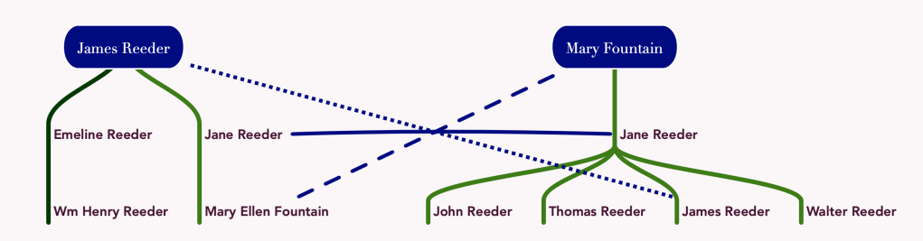
Reeder Siblings | marriages

Known Information

James, John, and Thomas Reeder and Mary Ellen (Reeder) Fountain lived in DC after the Civil War.

Sources

Census

1870; Census Place: Washington Ward 3, Washington, District of Columbia; Roll: M593_124; Page: 475A

1870; Census Place: Washington Ward 3, Washington, District of Columbia; Roll: M593_124; Page: 475B

1870; Census Place: Washington Ward 3, Washington, District of Columbia;Roll: M593_124; Page: 449B

Marriage Records

District of Columbia, Marriage Records, 1810-1953 | ancestry.com


United States, Freedmen’s Bureau Marriages, 1861-1872 | familysearch.org

City Directory

District of Columbia Birth Returns, 1874-1897 | familysearch.org

Birth Certificates

Reeder, Baby, 9236, 20 Nov 1876 | DC Archives

Reeder, Baby, 28331, 16 Jan 1882 | DC Archives

Reeder, Baby, 36254, 15 May 1882 | DC Archives

Three Reeder brothers, James, John, and Thomas were recorded in the 1868 Washington City Directory as living at M and 6 NE, which is near the Kendall Green Barracks. Bank records also list them as the brothers of Mary Ellen Fountain.

James Reeder

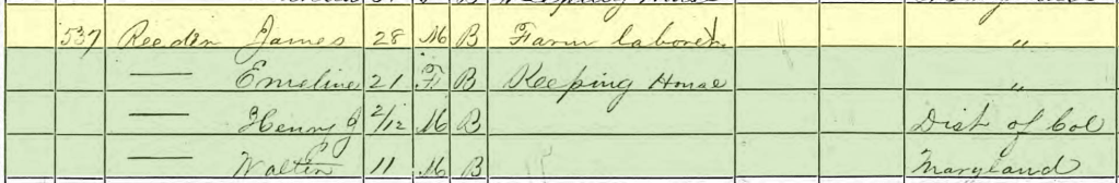
James was living with Emeline, his wife, and their sone Henry J. in 1870. Walter Reeder, age 11, is also living with them. Based on the bank records of Mary Ellen Fountain, Walter is James’ younger brother.

DC Marriage records lists a marriage for James Reeder and Emeline Dorsey on 13 Aug 1868. A birth record for a daughter born in 1876 lists both James Henry Reeder and Emeline Dorsey Reeder as the parents, and that they both were born in St. Mary’s County, MD. A birth record for a daughter born in 1883 lists Emeline’s last name was West, but provides the mother’s birthplace as St. Mary’s County

John Reeder

John Reeder is living with his wife, Cora, and their son, Willie, who was born in DC in 1868; Cora collected rations in January 1868 due to “sickness”, it is possible that in addition to any number of illnesses suffered by freedpeople as a result of malnourishment, exposure from poor shelter and clothing, that she was pregnant and sick with morning sickness.

They are living with is likely the younger siblings of Cora, suggesting that her last name is Key.

The Freedmen’s Bureau recorded marriages for freedmen that had not been formally recognized before. In 1867, John Reader and Cora Keys had their 1861 marriage in St. Mary’s County, MD, recorded in the DC Bureau They listed that they had one child, which suggests that they had an older child prior to Willie. A priest named Moore married them.
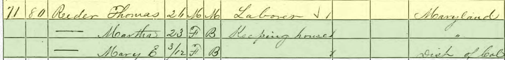
Thomas Reeder

Thomas is living with his wife, Martha, and their daughter Mary E. They do not have any other family living with them.

DC Marriage Records lists Thomas Reeder’s marriage to Martha Colbert in June 1867. An 1882 birth certificate for their son lists her maiden name as Calbert and that she was born in Prince George’s County.

Mary Ellen Reeder

Mary E Fountain is living near her brother, Thomas Reeder, just a few households away in the census. She is living with her husband Benj. F. Fountain.

DC Marriage Records lists Mary Ellen Reeder’s marriage to Benj Franklin Fountain in June 1866. No children have been located for them.

Further Research Needed:

  • Research the Key, Dorsey and Reeder family in St. Mary’s County
  • Research the Colbert family in Prince George’s County
  • Research the Fountain family in Virginia

related posts

James Reeder | USCT

Known Information

James Reeder had an account in the Freedmen’s Bank. He identified his wife and child and mother on the depositor slip. Additionally, he identified St. Mary’s County as his birth place.

Sources

Plan of Fort Monroe

Sneden, Robert Knox. Plan of Fortress Monroe, Virginia, March 6. [to 1865, 1862] Map. https://www.loc.gov/item/gvhs01.vhs00203/.

Service Records

The National Archives at Washington, D.C.; Washington, D.C.; Compiled Military Service Records of Volunteer Union Soldiers Who Served with the United States Colored Troops: 1st through 5th United States Colored Cavalry, 5th Massachusetts Cavalry (Colored), 6th United States Colored Cavalry; Microfilm Serial: M1817 | ancestry.com

Service records show that James Reeder served in Company K of the 1st US Calvary of Colored Troops, which was attached to Camp Hamilton at Fort Monroe in Virginia.

Fort Monroe

Stampede of slaves from Hampton to Fortress Monroe. United States Fort Monroe Hampton Virginia, 1985. [? from a Print In1861] Photograph. https://www.loc.gov/item/92515012/.

His services records indicate that he enlisted in February of 1864. One sheet indicates Camp Nixon which was north of Georgetown near District of Columbia, and the second sheet indicates Fort Monroe. It is possible that he made his way to DC from St. Mary’s and then was dispatched to Fort Monroe once he enlisted, as his arrival in Fort Monroe is recorded as Mar 1864.

Fort Monroe sits near Hampton Roads and guards the harbor at Old Point Comfort. In 1861, three enslaved men escaped their bondage and asked Gen. Butler to harbor them rather than return them to their enslavers. Butler contended that since the enslavers were in open rebellion against the US, the enslaved were “contraband of war” and did not need to be returned. As a result, the enslaved made their way to Fort Monroe to free themselves from slavery, the media calling it a “stampede”. The Fort became known as “Freedom’s Fortress”. Gen. Butler helped to establish camps for the freedpeople, providing clothing and food, and finding jobs and training for them. Several of the refugees joined the military. This cartoon from the 1860s (drawn with racist tropes in its imagery and language) depicts the “contraband” policy that Butler established.

He was nineteen when he enlisted. His service records do not document any injuries or illness, suggesting that he stayed with his company throughout the war. During May of 1864, it indicates that his company was dispatched to guard cattle, a common duty when the US Army first starting enlisted Black men into the US Army during the Civil War, especially along the James River and the road up to DC from Richmond.

He died in 1897 and was buried in section 27 of Arlington National Cemetery.

Further Research Needed:

  • Research the 1st Regiment of the US Colored Calvary

related posts

The Reeders | Freedmen’s Bank Records

Known Information

Thomas and John Reeder owned property together on 1st St NW

Sources

Bank Records

Registers of Signatures of Depositors in Branches of the Freedman’s Savings and Trust Company, 1865-1874. Washington, D.C.: National Archives and Records Administration. Micropublication M816, 27 rolls | ancestry.com

Freedman’s Savings and Trust Company’s was established to allow freedmen to deposit their savings in 1865; it closed in 1874 due to mismanagement. The bank kept records of depositors which included some demographic data including place of birth and family members.

These records show the family connections between the James Reeder family with the Mary Fountain family.

Further Research Needed:

  • Locate the Reeder family in St. Mary’s County
  • Locate the siblings in the 1870 Census
  • Locate marriage records for the Reeder siblings, esp James, Mary, and Thomas

related posts

Martha Reeder | Freedman’s Bureau

Known Information

Thomas and Martha Reeder were living in DC during the 1870 census.

Sources

Print

Taylor, James E., Artist. Glimpses at the Freedmen’s Bureau. Issuing rations to the old and sick / from a sketch by our special artist, Jas. E. Taylor. Richmond Virginia, 1866. Photograph. https://www.loc.gov/item/2009633700/

Freedman’s Village, Arlington i.e., Alexandria, Va. United States Arlington Alexandria Virginia, None. [Photographed between 1861 and 1865, printed between 1880 and 1889] Photograph. https://www.loc.gov/item/2014645761/

Map

Boschke, A, D McClelland, Hugh B Sweeny, Thos Blagden, and Blanchard & Mohun D. Mcclelland. Topographical map of the District of Columbia. Washington: D. McClelland, Blanchard & Mohun, 1861. Map. https://www.loc.gov/item/88694013/

United States, Freedmen’s Bureau Ration Records,1865-1872

District of Columbia, United States, NARA microfilm publications M1055. Records of the Bureau of Refugees, Freedmen, and Abandoned Lands, 1861 – 1880, RG 105. (Washington, D.C.: National Archives and Records Administration, 1969-1980); roll 16 | familysearch.org

Newspapers

The Baltimore Sun 
Baltimore, Maryland
14 Jan 1868, Tue  •  Page 4

The Freedman’s Bureau was a US government agency from 1865-1872 charged with directing provisions, clothing, fuel “for the immediate and temporary shelter and supply of destitute and suffering refugees and freedmen and their wives and children”

The Bureau kept records of what provisions, or rations were distributed.

In 1868, they recorded that Martha Reeder was provided $2.00 worth of groceries as she was unemployed. They listed her residence as Kendall Green. In addition to Martha, Cora Reeder was also recorded as residing at Kendall Green and receiving rations due to sickness.

This sketch is of a Richmond Bureau Office distributing rations “to the old and sick”

Kendall Green

After the Civil War, the US Government converted military barracks into housing for freepeople. Kendall Green Barracks, located on the northeast boundary of the city was one of the converted barracks. Kendall Green was located along Boundary Ave, in the northeast quadrant of the city. On the map, it is directly “north” of the capitol building, between Delaware and Maryland Avenues. The northern edge of the camp was at M and Boundary Ave.

In 1867, Kendall Green became the housing for the freed people who were unable to pay their rent and the Freedmen’s Bureau began to transfer nonpaying tenants and “those that pay very irregularly” to Kendall Green and those who could pay to housing closer to the city. In a newspaper article, the barracks are described a light one-story frame tenements with twenty-one rooms, housing 250 freedpeople.

Picture of the school established at Freedmen’s Village in Alexandria, VA

These barracks have been fitted up for dwellings for the freed people to be rented for very low rates, in order to get them out of the wretched shanties in which such numbers of them have hitherto lived (and died). But they are located so far from one side of the city, that they are taken up slowly.

Letter from A. E. Newton reporting on the school built near Kendall Green Barracks as listed in the National Freedman, A Monthly Journal, Vol 11, No 5 May 1866 (147)

Further Research Needed:

  • Determine the relationship between Martha and Cora Reeder
  • Identify other Reeders recorded in the Freedmen’s Records

related posts

Thomas Reeder | property on 1st Street NW

Known Information

James Reeder came to DC during the Civil War.

Sources

1870 Census

1870; Census Place: Washington Ward 3, Washington, District of Columbia;Roll: M593_124; Page: 449B

Map

Boschke, A, D McClelland, Hugh B Sweeny, Thos Blagden, and Blanchard & Mohun D. Mcclelland. Topographical map of the District of Columbia. Washington: D. McClelland, Blanchard & Mohun, 1861. Map. https://www.loc.gov/item/88694013/.

City Directory

Washington, District of Columbia, City Directory, 1870-1878, exclusive of 1872 which is incomplete

Newspapers

Evening Star 
Washington, District of Columbia
24 Jun 1867, Mon  •  Page 4

Evening Star 
Washington, District of Columbia
26 Sep 1872, Thu  •  Page 22

In 1870, Thomas Reader is listed in the City Directories as living at 1421 1st NW; he was living with his wife and infant daughter. The city directory listed him as a waiter, the census as a laborer. Marriage records in DC show the Thomas and Martha were married three year earlier in 1867.

His residence was almost to the edge of the official City of Washington. Located at O and 1st street NW, it was just a few blocks from Boundary Ave (now Florida Ave), which served as the boundary between the city and the county. This area of the City was still agricultural in nature, especially in comparison to the areas around Pennsylvania Avenue near the Capitol and the White House. The houses are sparser and farther apart. Large agricultural estates still dominated the landscape of the County, though a few were being broken into subdivisions, like Le Droit Park. In 1888, when Sanborne made Fire Insurance maps for the City of Washington, square 616 and its environs were not included in the atlas, presumably because there were not enough properties, or properties to be insured, built in this neighborhood. The Topographical map shows the contrast in population density between the area near Boundary Avenue and closer to the Capitol. Square 616 is two blocks south of Mrs. E Beale’s property.

In 1872, the Evening Star ran tax assessments on properties in the City, showing that Thomas and John Reeder owned part of lot 12 of square 616 in the city. That specific property had been put up for sale in 1867. Auctioners Cooper and Latimer advertised it as “unimproved property”. This suggests that when the property bought there were minimal buildings on the lot.

The city directories show that Thomas lived in an about 1421 1st NW throughout the 1870s until 1878:

  • 1871: 1417 1st NW
  • 1873: 1423 1st NW
  • 1874: 1421 1st NW
  • 1875: 1st near P NW
  • 1876: 1421 1st NW
  • 1877: 1419 1st NW

Further Research Needed:

  • Identify the relationship of John Reeder to Thomas Reeder
  • Locate the land records in the DC Archives

related posts

Thomas Reeder | Jackson alley

Known Information

Thomas Reeder lived in DC after the Civil War.

Sources

Newspapers

Evening Star 
Washington, District of Columbia
23 Jul 1866, Mon  •  Page 2

Evening Star 
Washington, District of Columbia
13 Jul 1867, Sat  •  Page 3

Evening Star 
Washington, District of Columbia
27 Jul 1867, Sat  •  Page 3

Evening Star 
Washington, District of Columbia
26 Sep 1867, Thu  •  Page 3

Evening Star 
Washington, District of Columbia
07 Jun 1873, Sat  •  Page 4

Evening Star 
Washington, District of Columbia
24 Dec 1877, Mon  •  Page 2

Map

Gamble, W. H, and S. Augustus Mitchell. Plan of the city of Washington: the capitol sic of the United States of America. [Philadelphia: S. Augustus Mitchell Jr, 1869] Map. https://www.loc.gov/item/88693479/

Sanborn Fire Insurance Map from Washington, District of Columbia, District of Columbia. Sanborn Map Company, 1888. Map. https://www.loc.gov/item/sanborn01227_001/.

City Directory

Washington, District of Columbia, City Directory, 1864

Print

Kollner, Augustus, Artist. Tiber Creek north-east of the Capitol. Washington, D.C. Washington D.C. United States Tiber Creek, 1839. Photograph. https://www.loc.gov/item/2004662005/

Currier & Ives, Publisher, and Charles R Parsons. The City of Washington birds-eye view from the Potomac-looking north / drawn by C.R. Parsons. United States Washington D.C. District of Columbia Washington, ca. 1880. New York: Published by Currier & Ives. Photograph. https://www.loc.gov/item/90716011/

Swampoodle

The Tiber Creek ran northeast of the Capitol, no longer a contained canal. When there were storms, the creek often flooded, washing away bridges and filling basements. Due to the swampy nature of this floodplain and the left behind puddles, the area near the Union Pr. Office was called Swampoodle.

In this rendering of Washington, Massachusetts Ave intersects with North Capitol Street near the center seam of the picture. The blocks north of this intersection was called Swampoodle and contained Jackson Alley.

Jackson Alley was considered the heart of Swampoodle, and ran between G and H street, along the Printing Office. Originally an Irish enclave, when refugees from slavery arrived in the City of Washington during the Civil War, African-American families also found homes in Swampoodle.

1880 Census

In the 1880 Census, Thomas Reeder was recorded living with his family with Robert Childs and his family in 71 Jackson Alley. Thomas and his wife Martha had three children: Mary E, 10, Joseph, 8, and Georgiana, 4. Thomas and his wife, Martha, were born in Maryland while their children were all born in DC.

Mary E. is marked as having attended school.

The City Directories for 1883-1901 show Thomas living at various addresses in Jackson Alley; sometimes at #65, or #50, or #34. The variety of house numbers suggests that the Reeder family shifted as rent prices and space shifted in the alley. The excerpt from the Sanborn Fire Insurance maps shows the variation in size and that some homes were frame and some were brick. The end of the block near the Printing Office was more industrial in nature, containing a livery station, a factory and storehouse.

Further Research Needed:

  • Locate residences in earlier censuses

related posts