smith’s purchase: carter-bowie alliance

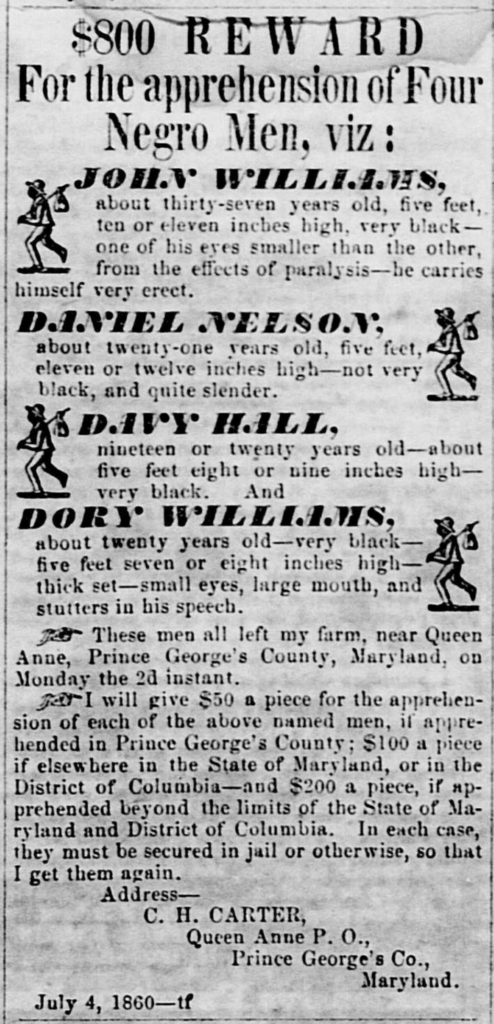
The 1851 marriage of Alice Carter, daughter of Charles H. Carter and Rosalie E. Calvert, to Oden Bowie, solidified a powerful alliance between two prominent enslaving networks. This union not only consolidated significant landholdings but also intertwined the complex kinship networks of the hundreds of Black people they held in bondage, whose forced labor was the bedrock of their wealth and political power.

Alice Carter was a scion of the Calverts, descendants of the colonial proprietors of Maryland, and the Carters of Shirley Plantation.  Her father, Charles H. Carter operated the “Goodwood” plantation in the Queen Anne’s District, which was inherited from his wife’s family: George and Rosalie Calvert of Riverdale.  

Oden Bowie was the heir of William Duckett Bowie and Eliza Mary Oden, with connections to Bowie, Duckett and Oden networks, with their extensive landholdings, including the “Fairview” plantation in the Darnall’s Grove Neighborhood, were equally entrenched in the economic and political fabric of the state. Oden Bowie, a rising figure in Maryland politics, would later become governor.

Excerpt of the 1861 Martenet Map showing the location of Fairview in the Darnall’s Grove neighborhood.

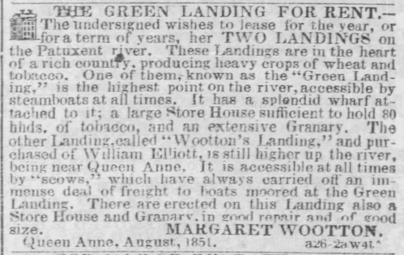
While Oden and Alice Bowie resided at “Fairview” in the Darnall’s Grove Neighborhood, they purchased a consolidated tract of 471+ acres, composed of land from four older tracts: Smith’s Purchase, part of Dundee, part of Strife, part of Swanson’s Lot in the Wootton’s Landing Neighborhood (CSM 4:177).  

Hienton and Martenet’s map shown side-by-side with land tracts and landowner name marked. See page on geographic mapping for more detail

This purchases complicates analysis of Oden Bowie’s 1867 compensation list, as the list does not specify which estate the enslaved people labored on (i.e., Fairview or Smith’s Purchase).  Another complication in the reconstruction of kinship groups  is the lack of transparency around the transfer of ownership during land purchases.  Research has shown that land purchases within Queen Anne District may only document the transfer of land with its metes and bounds, but would also contain the transfer of the people who labored in the fields.  For example, the Tilghman kinship group conveyed within the Hall network from Francis Magruder Hall to Notley Young’s son in 1826 Hall’s will appears in Charles C. Hill’s 1867 compensation list; Charles C. Hill purchased Elverton Hall from the Young family in the 1850s.

A review of the 1850 and 1860 Slave Schedules show the change in population of the communities enslaved by Oden Bowie.  In 1850, prior to his marriage and the acquisition of Smith’s Purchase, the census enumerated 47 people.   In 1860, at the dawn of the Civil War, the census enumerated 101 people.  The 1867 Compensation List submitted by Bowie lists the names of 103 people

goodwood: calvert-carter alliance

George Calvert‘s position as a nexus in the Wootton’s Landing Neighborhood was cemented not only through his vast landholdings but also through strategic affinal kinship ties that extended his influence into Virginia. This was a common practice within the planter class to consolidate wealth and forge powerful alliances. This pattern is evident in the 1830 marriage of his daughter, Rosalie Eugenia Calvert, to Charles Henry Carter, a son of the Carter family of Shirley Plantation, one of Virginia’s most powerful slaveholding dynasties. This alliance forged a strategic affinal bridge between a powerful Maryland enslaver network and the Carter dynasty of Virginia.

The scale of the Calvert operation that Carter would come to control is evident in earlier tax assessments. While George Calvert resided at Riverdale in the Bladensburg District in the 19th century, his maintained his Mount Albion plantation in the Wootton’s Landing Neighborhood. In 1828, George Calvert was assessed for 2,777 acres and 93 enslaved people in the Horsepen and Patuxent Hundreds. By 1833, his personal property assessment for the Third District (including what would be Queen Anne District) showed an increase to 100 enslaved people on one list, likely representing the workforce at Mount Albion. Another 1833 list for the same district enumerated 26 enslaved people, possibly those at Oatlands, another Calvert property in the Partnership Neighborhood of Queen Anne District.  

Image from 1836 Deed of Trust | mdlandrec.net
Calvert George H_Rosalie Eugenie Carter + husband_AB-11-32-Deed of Trust

Calvert would transfer this property to his daughter in the 1830s.  This transfer of property was not merely a familial gift but a calculated transmission of a massive agricultural operation and the enslaved labor force that made it profitable. A Deed of Trust dated November 12, 1836, solidified this alliance and detailed the significant transfer of wealth. The indenture documents how George Calvert conveyed a substantial estate into a trust for his daughter Rosalie’s sole and separate use, managed by himself and Robert E. Lee of Arlington. The assets included a 728 ½-acre tract of land known as “Goodwood,” formerly the core of Mount Albion. Critically, the deed also explicitly transferred the legal title to a community of enslaved people, listing 42 men, women, and children by name and age in an attached schedule. This single transaction established the material basis for Charles H. Carter’s standing within the Prince George’s County enslaver network.

The enslaved population at Goodwood grew under Carter’s control, from the initial 42 individuals in 1836 to 52 by the 1840 census, 58 in 1850, and 76 by 1860. After Rosalie Carter’s death in 1848, the land was conveyed directly to her husband, fully transferring this portion of the Calvert family’s Maryland wealth into the Carter lineage. By 1860, Charles H. Carter’s real estate was valued at $70,000, and his personal estate—a value primarily derived from the external market value of the people he enslaved—was assessed at $55,000. This concentration of wealth and power in the Wootton’s Landing neighborhood was further solidified in the next generation through the marriages of Carter’s daughters, Rosalie Eugenia Carter and Alice Carter, into the Francis Magruder Hall and Oden Bowie families, respectively, perpetuating the cycle of elite kinship consolidation within Prince George’s County.

The reconstruction of kinship networks among the people enslaved at Goodwood is fundamentally obstructed by a documentary void. Two key record sets that typically name enslaved individuals from the late antebellum and emancipation era are missing: a probate inventory for Rosalie E. Carter and a post-emancipation compensation claim from Charles H. Carter. While Rosalie E. Carter created a will, it functioned primarily to affirm the conditions of the 1836 Deed of Trust, which stipulated that all real and personal property would be conveyed to her husband for his lifetime, precluding the need for a separate probate inventory. Furthermore, Charles H. Carter, as a nephew of Robert E. Lee, did not file a compensation claim in 1867 for his formerly enslaved human property, likely due to his Confederate ties.Consequently, research must proceed using a limited set of documents. The primary sources are the 1836 Deed of Trust, which provides a schedule of 42 named individuals, including one, Nelly Brown, with a family name, and the anonymous demographic data in the 1840, 1850, and 1860 U.S. Census Slave Schedules. This direct evidence is supplemented by three runaway slave advertisements that identify additional family names: Lloyd Wood, William Brown, John Williams, Dory Williams, Daniel Nelson, and Davy Hall.

Adverstisements

Planter’s Advocate, July 4, 1860 | MSA
Planters Advocate, Apr 20 1853 | MSA
Daily National Intelligencer, Dec 16 1839 | newspapers.com

📍 wootton’s landing

Wootton’s Landing Neighborhood, located in the southeastern part of Queen Anne District, bordered the Patuxent River to the east and Marlboro District to the south. The neighborhood’s namesake, Wootton’s Landing, provided direct control for enslavers over the collection, storage, and transport of agricultural commodities produced by enslaved labor. Martenet’s 1861 map shows the landing situated south of Queen Anne Towne and near a mill. This area’s proximity to the Patuxent River, a vital waterway for connecting inland agricultural production to the global market system, and its shared border with Marlboro District, which contained the county seat of Upper Marlboro, underscored its economic significance in pre-emancipation Prince George’s County.

Excerpt from Simon Martenet’s Map of Prince George’s County highlighting Queen Anne District.
Edits by the researcher from original map sourced from Library of Congress.

An 1851 advertisement placed by Margaret Wootton in The Baltimore Sun details the logistical importance of these riverfront properties. In seeking to lease her two landings, Wootton described them as being ‘in the heart of a rich country, producing heavy crops of wheat and tobacco,’ a direct acknowledgment of the output generated by the region’s enslaved workforce.  The landings had large stores and granaries to hold both tobacco and grain.  Some of the landings were accessible by steamboats, while others required scows, flat bottom sailboats to transfer the goods to the larger vessels likely traveling to Baltimore where merchants would handle the inspection, sale, and final shipment of the hogsheads to international buyers. 

advertisement
THE GREEN LANDING FOR RENT.– The undersigned wishes to lease for the year, or for a term of years, her TWO LANDINGS on the Patuxent river. These Landings are in the heart of a rich country, producing heavy crops of wheat and tobacco. One of them, known as the “Green Landing,” is the highest point on the river, accessible by steamboats at all times. It has a splendid wharf attached to it; a large Store House sufficient to hold 80 bhds. of tobacco, and an extensive Granary. The other Landing, called “Wootton’s Landing,” and purchased of William Elliott, is still higher up the river, being near Queen Anne. It is accessible at all times by “scows,” which have always carried off an immense deal of freight to boats moored at the Green Landing. There are erected on this Landing also a Store House and Granary, in good repair and of good size. MARGARET WOOTTON. Queen Anne, August, 1851.
Baltimore Sun, Sep 16, 1851 | newspapers.com

calvert nexus: influence and alliances in the Wootton’s Landing neighborhood

This economic significance was directly tied to the individuals who comprised the enslaver networks in the Wootton’s Landing Neighborhood, profoundly shaping agricultural production and commerce.  The enslaver networks of Wootton’s Landing were influenced by George Calvert (1768-1838), who married Rosalie Stier, and was one of the wealthiest landowners and enslavers in Prince George’s County during the Imperial Tensions Generation. 

The enslaver networks of Wootton’s Landing were dominated by figures like George Calvert (1768-1838), who married Rosalie Stier and, during the Imperial Tensions Generation, became one of the wealthiest landowners in the county. As a lineal descendant of Benedict Swingate Calvert of Mt. Airy, George Calvert inherited a vast portfolio of land that he consolidated into the Mount Albion plantation. This holding, totaling 2,233 acres, was composed of numerous tracts, including “Swanson’s Lot,” “Part of Coolspring Manor,” “Addition to Leaving,” “Griffith’s Purchase,” “Part of Cuckolds Delight,” and “Part of Riley’s Landing,” among others, firmly rooting his economic power in the Wootton’s Landing neighborhood.The 1798 Federal Direct Tax provides a stark inventory of the infrastructure required for such an operation. On this land, Calvert maintained a frame dwelling house, a kitchen, a ‘brick cow house and stables,’ a large corn house, and, critically, an overseer’s house and 14 quarters for enslaved people. This collection of buildings documents a large, forced-labor camp designed for the mass production of tobacco and other crops. The tax list assessed Calvert for 69 enslaved people, making him the largest single enslaver in the Patuxent and Horsepen Hundreds. The scale of his operation, built on the labor of these 69 individuals, surpassed even that of the Jesuit-owned White Marsh plantation managed by John Ashton.