Black communities in queen anne district

Original Map from Library of Congress
welcome to the “Forest”: a map of the past
The “Forest of Prince George’s County” was a name that stood in stark contrast to its economic and physical reality. Described in 1861 by a Northern Observer writing for the New York Times as a “miscalled” name for what was originally an “unbroken Forest,” the area had been transformed by nearly two centuries of tobacco cultivation into “one continuous plantation” where “scarcely any woods left”. This fertile district was the great tobacco region of Maryland, powered by a brutal system of chattel slavery.
an economy built on tobacco and enslavement
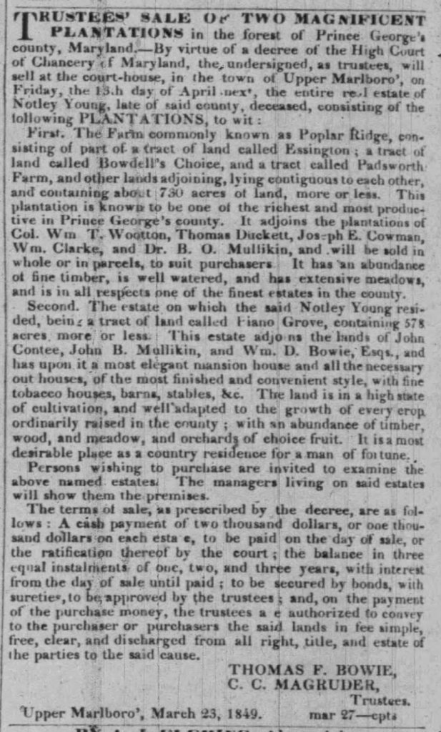
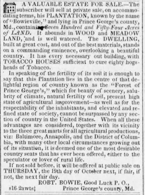
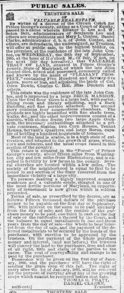
The path to economic and social prominence in the “Forest” was exclusively through the cultivation of tobacco, a system dependent on access to large tracts of land and an enslaved labor force. Advertisements for estates in the region boasted of its “natural fertility of soil” and its status as one of the “richest and most productive” areas in the county, “well adapted to the growth of every crop ordinarily raised,” especially tobacco. The infrastructure of these plantations was built around the cash crop, featuring “fine tobacco houses” and massive barns “capable of holding a hundred hogsheads of tobacco”.
This agricultural engine was fueled by a demographic reality where enslaved Black people outnumbered white residents by a factor of “two or three slaves to one white person”. Planters turned to the mass importation of Africans as a forced labor source to expand their farms into plantations at the beginning of the 18th century. The residential compounds of these estates reflected this hierarchy, with an “elegant mansion house” for the enslaver and designated “Tenant Houses” and “Servant’s Quarters” for the laboring population.
an “elevated society” and its enslaved foundation
The society of the “Forest” was dominated by wealthy planters who established their “desirable country seats” by extracting labor from the people they enslaved. While planters promoted their community as having an “elevated and refined state of society” and a “respectability of the inhabitants, [that] cannot be surpassed,” they simultaneously employed overseers and managers to enforce the brutal labor demands of the tobacco economy. A correspondent for the New York Times offered a blunter assessment, stating that “the whole tone and character of society is similar to that of South Carolina and Alabama.”
Despite its rural isolation, the district was economically connected to “the three great marts for all agricultural productions, viz: Baltimore, Annapolis, and the District of Columbia,”. This access was facilitated by ports like the historic Queen Anne Towne, situated within the district on the banks of the Patuxent River, from which planters shipped hogsheads of tobacco into the global Atlantic economy.
The political geography of this region evolved alongside its economy. During the colonial period, the area was organized into administrative units called “Hundreds,” a system inherited from English common law. After the American Revolution, these Hundreds were replaced by election districts, a shift designed to enfranchise the white male landowners who now governed the new Republic. By the 1840s, these districts were subdivided further, and the area once known simply as the Marlboro District was carved up. From it, Queen Anne District—the Seventh Election District—was formally established.
a tale of two maps
The “Forest of Prince George’s County” and Queen Anne District serve as a scaffold upon which the lives of the enslaved can be reconstructed. The official records of the era—wills, inventories, and deeds—were designed to document the transfer of property, not the bonds of family. Enslaved individuals appear as entries on a ledger, their humanity secondary to their economic value. By placing these individuals within a specific location, we can begin to uncover the hidden world of their social and familial connections. Proximity on a plantation or in a neighborhood becomes a crucial piece of indirect evidence, suggesting the presence of a familial cohort or a broader kinship constellation that spanned across property lines. This is the central task of this research: to move beyond the enslavers’ map of land tracts and build a parallel map of kinship, revealing the resilient family structures that endured within the brutal economy of chattel slavery.
Blog Posts about Individuals and Communities
genetic threads, historical lives: the story of Maria Matthews and Washington Lee
genetic thread: a DNA connection A DNA match between descendants initiated an investigation into the probable shared ancestry of two Black individuals living in Prince George’s County after emancipation. Washington Lee, a Civil War veteran, appeared in the Western Branch Neighborhood of Queen Anne District after the Civil War without visible connections to any kinship…
at Her request: navigating the Unraveling of the macgill estate
Background Reading the tapestry of macgill’s estate The story of Polly is one of resistance against a world designed to commodify her existence. Sold from the estate of her long-time enslaver, she escaped her new owner in a daring attempt to re-stitch the torn fabric of her own kinship community. To understand her actions, one…
paper trail’s Pulse: dissecting the search for Polly
The Baltimore Sun’s printer placed the ad in the last column of page 2, underneath a bounty for Peter Culver who had absconded with a “free boy, hired by me, named Alexander” and an ad for Ohio Flour. Within this mundane context of commerce and control, William E. Peach’s advertisement primarily sought the conviction of…
planter panic of 1857
a man Undone merchant of queen anne William B. Harwood operated as a merchant in Queen Anne on the Patuxent River during the 1850s. The 1850 census enumerated his household, including a wife and child, and recorded his modest real estate valued at $1,200, likely a town lot and store. An 1852 Bill of Sale…
fire by an incendiary: a microhistory of a forgotten act of Rebellion
empires of Leaf and Labor Queen Anne District was situated in the “Forest of Prince George’s County”, and a contributor to the New York Times described it as “the great tobacco region of Maryland, and probably no other territory of equal extent in America produces so much of that famous weed.” [Dec 6, 1861] This…
