Reconstructing the families of the enslaved in Queen Anne District requires a specific methodology. The official records—wills, deeds, and inventories—primarily document a geography of property, listing individuals as assets. By systematically plotting the locations of enslaved people recorded in these documents, a second, less visible map can be constructed: a map of kinship. This spatial analysis is central to the research. It uses the landscape defined by enslavers to identify patterns of co-residence. Proximity on a plantation or within a neighborhood provides indirect evidence for potential family bonds, allowing for the reconstruction of the social and familial networks that the system of chattel slavery obscured.

Edits (saturation, brightness, contrast) by the researcher from original map sourced from Library of Congress.
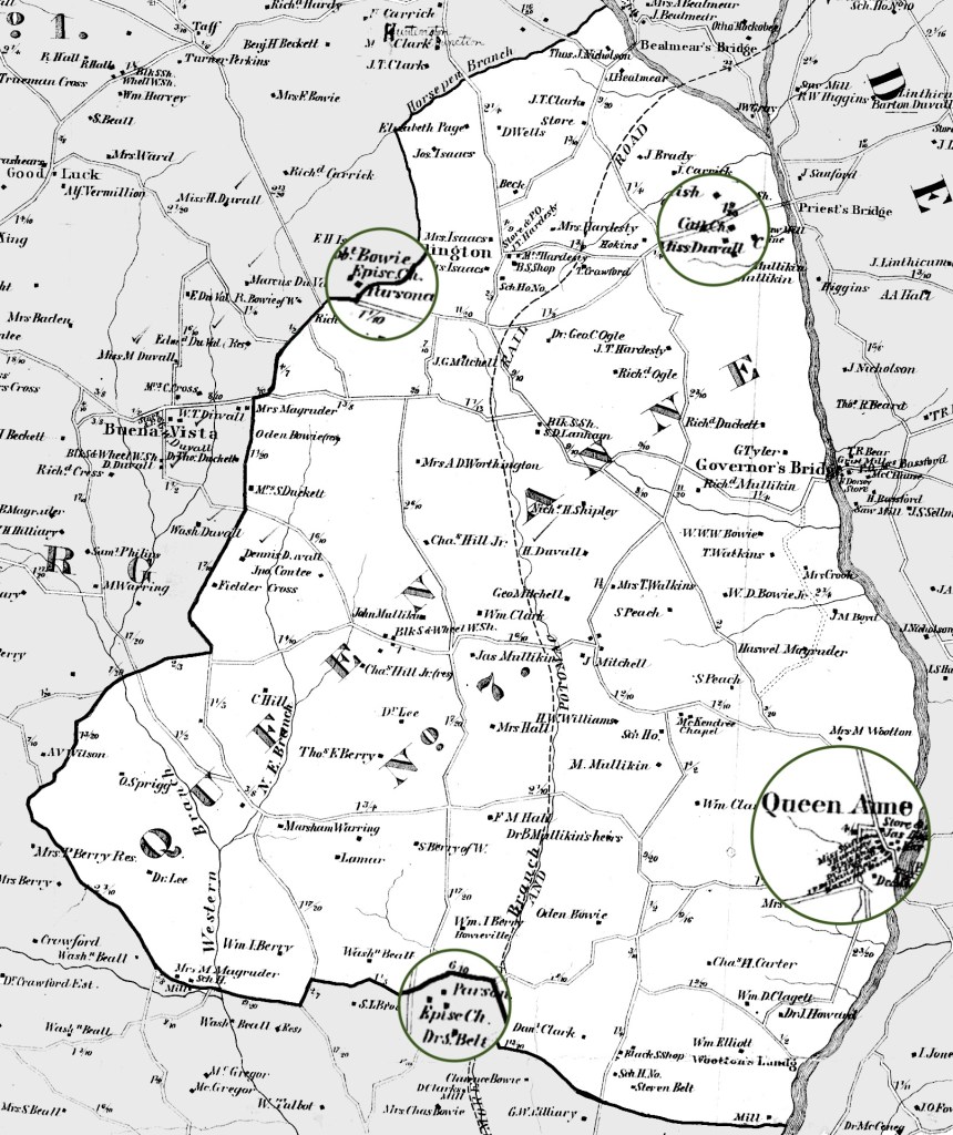
Queen Anne District, located in northeastern Prince George’s County, Maryland, is central to understanding the history of chattel slavery in the region. Bordered by the Patuxent River to the east, the district was formed from a partition of Marlboro District (Third District) during the antebellum period. The labor demands of tobacco cultivation initially relied on indentured servants but later shifted to the forced labor of enslaved Africans. Queen Anne Towne, situated along the Patuxent River, functioned as a critical port for the export of tobacco and the import of goods and enslaved people, integrating the district into the broader Atlantic economy.
Before its formal establishment as a district, the area was known as Queen Anne Parish, with St. Barnabas Episcopal Church (the Brick Church) and Holy Trinity Church serving as key anchors. Church Road connected these two religious centers, running north and south across the parish. The Catholic Jesuit Plantation, White Marsh, also lay within the boundaries of the future Queen Anne District, encompassing nearly 2000 acres along the Patuxent River near the area later known as Priest’s Bridge.
Edits by the researcher from original map sourced from Library of Congress.
In the 1730s, the land comprising Queen Anne District consisted of the Collington, Patuxent, and Western Branch Hundreds and saw settlement by wealthy white colonizers. Over 40% of households in this early period held enslaved people, with a significant number being large planters. This area, part of the “Forest of Prince George’s County,” possessed fertile land well-suited for tobacco cultivation, a factor crucial to its economic development. The formal establishment of the 7th Election District, designated as Queen Anne’s District, occurred in 1843 through Chapter 255 of the Acts of 1843, marking a political reorganization of territory previously belonging to Marlboro District.
Neighborhoods
Geographic Areas within Queen Anne
For a more detailed analysis of enslaved communities within this project, I have divided Queen Anne District into distinct neighborhoods based on geographical features, historical land tract boundaries, and key antebellum hubs. These delineated areas—📍Collington, 📍Governor’s Bridge, 📍Queen Anne, 📍 Wootton’s Landing, 📍Darnall’s Grove, 📍Partnership, and 📍Western Branch—enable a nuanced understanding of community formation and potential kinship ties within smaller, geographically coherent units. This neighborhood framework, informed by historical maps and property records, also facilitates consistent tagging of enslavers and estates in research. Analyzing data at this neighborhood level allows for the identification of localized patterns of enslavement and potential proximity of related individuals. These neighborhoods, therefore, should be understood as a modern analytical framework conceived by the researcher to facilitate analysis, not as communities formally recognized by the historical inhabitants of the district.

Edits by the researcher from original map sourced from Library of Congress.
Mapping Sources
The geographic mapping of enslaved communities in Queen Anne District relies on key historical cartographic resources:
- 1861 Simon Martenet Map of Prince George’s County & 1878 G. M Hopkins Map of Queen Anne District (Prince George’s County): These 19th-century maps delineate the nine Election Districts of Prince George’s County, including Queen Anne (Election District 7), and features waterways, roads, towns, and proposed railways. Crucially, they identify landowners, which, when cross-referenced with the 1860 and 1870 Census, provides vital spatial context for historical records naming enslavers and the people they enslaved, as well as the post-emancipation communities. Analyzing the proximity of households, particularly those of formerly enslaved people and their former enslavers using census dwelling numbers, offers avenues for investigating the spatial dynamics of post-emancipation communities and potential continued connections.

Edits (saturation, brightness, contrast) by the researcher from original map sourced from Library of Congress.

Edits (saturation, brightness, contrast, rotation to show North as up, repositioning of map title) by the researcher from original map sourced from Library of Congress.
- Louise Joyner Hienton’s Land Tract Map (1959): Created by Louise Joyner Hienton, this map meticulously documents the historical land tracts within Prince George’s County, drawing upon original surveys and grants at the Maryland State Archives. By overlaying these original land tracts onto a 1954 map of the county, Hienton’s work provides the historical property boundaries referenced in later land records of enslavers. Integrating this map with the 1861 Martenet Map allows for an understanding of how these original land tracts evolved into 19th-century landholdings. This connection is essential for tracing enslaver networks in the antebellum period and for reconstructing kinship groups by understanding the spatial relationships between different estates across time.

